Keep Victoria Falls Wild
Conservation and Development of the Victoria Falls
UNESCO World Heritage Site (1989)
Outstanding Universal Value
Protection and Conservation
Divided and Dissected
The following text has been adapted (with permission) from
researched and written by Peter Roberts and published in February 2026
UNESCO World Heritage Site (1989)
The Victoria Falls was designated as a World Heritage Site at the 13th session of the World Heritage Committee, held in Paris in December 1989, following the joint submission of the site by Zambia and Zimbabwe, known as the ‘State Parties,’ to the United Nations Educational, Scientific and Cultural Organization (UNESCO) for consideration on the exclusive global list. The World Heritage List is managed under the World Heritage Convention (1972), of which both countries are signatories. As parties to the convention, the two countries pledge to keep the Victoria Falls/Mosi-oa-Tunya World Heritage Site (VFWHS) ‘intact for future generations.’
The listing described the Falls as “the world’s greatest sheet of falling water and significant worldwide for its exceptional geological and geomorphological features and active land formation processes with outstanding beauty attributed to the falls i.e. the spray, mist and rainbows.” (UNESCO, 2022).
Covering an estimated area of 6,860 hectares, the majority of the Victoria Falls/Mosi-oa-Tunya World Heritage Site lies within the protected areas of the Mosi-oa-Tunya (covering 3,779 ha) and Victoria Falls National Parks (2,340 ha) on the Zambian and Zimbabwean sides of the river respectively and including the river and gorges extending 16 km downstream, as well as extending 15 km upstream as far as and including Palm and Kandahar Islands, the latter protected on the south bank within a 9 km section of river and adjoining riverside fringe (covering 741 ha) which is part of the upstream Zambezi National Park.
Originally the area proposed by the two countries for the site included a much larger area, incorporating the whole of the Mosi-oa-Tunya and Victoria Falls/Zambezi National Parks on the north and south banks respectively, before the World Heritage Commission recommended that the area should be reduced to concentrate on the core features of the Falls and river.
"The Committee commended the Governments of Zambia and Zimbabwe for demonstrating their commitment to co-operate in management of the site through the joint nomination. The Committee agreed to the joint inscription of the property on the basis that both Zambia and Zimbabwe had already agreed to reduce the limits of the nominated property to include only the Victoria Falls National Park, the northern half of Mosi-oa-Tunya National Park and a small portion of the riverine strip of Zambezi National Park in order to better concentrate on core features of the Falls area and the downstream gorges. The Committee requested the Secretariat to encourage Zambia and Zimbabwe to continue to consult together on this matter in cooperation with IUCN to reach agreement on final boundaries." (World Heritage Committee, 1989)
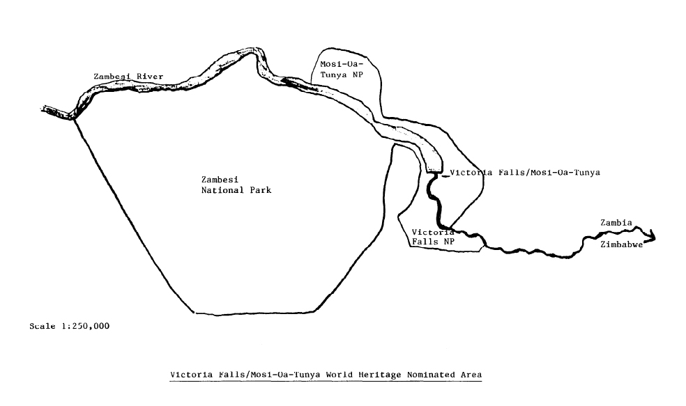
1989 map showing area of the Victoria Falls World Heritage Site
as originally proposed by the State Parties,
including whole of Zambezi National Park.
The area finally agreed for the boundary of the Victoria Falls/Mosi-oa-Tunya World Heritage Site (WHS) lies largely within the southern section of the Mosi-oa-Tunya National Park in Zambia and the whole of the Victoria Falls National Park and a small section of the Zambezi National Park in Zimbabwe. The site covers the upstream river corridor from above Palm and Kandahar Islands downstream to the Falls, and includes the gorges extending for some 16 kilometres below the Falls.
"The Mosi-oa-Tunya/Victoria Falls is the world’s greatest sheet of falling water and significant worldwide for its exceptional geological and geomorphological features and active land formation processes with outstanding beauty attributed to the falls i.e. the spray, mist and rainbows. This transboundary property extends over 6,860 ha and comprises 3,779 ha of the Mosi-oa-Tunya National Park (Zambia), 2,340 ha of Victoria Falls National Park (Zimbabwe), 741 ha of the riverine strip of Zambezi National Park (Zimbabwe).
"A riverine strip of the Zambezi National Park extending 9 km west along the right bank of the Zambezi and islands in the river are all within the Park as far as Palm and Kandahar Islands... The Mosi‐oa‐Tunya National Park boundary follows the left bank between the Sinde River and the Songwe Gorge, bounded in the North by Dambwa Forest Reserve and the Maramba Township. On the right bank, the Victoria Falls National Park is bounded by the river from 6 km above to 12 km below the Falls." (UNESCO, 2022)
Outstanding Universal Values
The World Heritage Site was inscribed for both geological and ecological values under natural criterion N (ii) and N (iii), since revised to criteria (vii) and (viii).
“The Victoria Falls/Mosi-oa-Tunya site is one of the world’s most spectacular waterfalls and still exists in a natural condition only partially affected by man. The site clearly meets natural criterion (ii) as an exceptional example of significant on-going geological processes. The Falls and associated gorges are an outstanding example of river capture and the erosive forces of water that are continuing to sculpture the hard basalts. The site does not meet criterion (Iv) as it is not a particularly important habitat for [endangered] species. Although one species (the Taita falcon) is scarce, it is not regarded as threatened.” (World Heritage Committee, 1989, p.68)
The key attributes of the property’s Outstanding Universal Values (OUV) are associated with the scale of the Falls, the ecological values of the eight gorges supporting endangered and migratory species, as well as the geological and geomorphological story told by the erosive force of water.
"Criterion (vii): The Mosi-oa-Tunya/Victoria Falls is the largest curtain of falling water in the world; it is 1708 m wide and with up to 500 million litres per minute descending at 61 m (Devil’s Cataract), 83 m (Main Falls), 99 m (Rainbow Falls), 98 m (Eastern Cataract). Eight spectacular gorges of igneous origin (i.e. comprising basalts) and several islands in the core zone serve as breeding sites for four endangered and migratory bird species, such as the Taita Falcon and Black Eagle. The riverine 'rainforest' within the waterfall splash zone is a fragile ecosystem of discontinuous forest on sandy alluvium, dependent upon maintenance of abundant water and high humidity resulting from the spray plume of about 500 m (at maximum height) that can be seen from a distance of 50 km and 30 km from Bulawayo and Lusaka roads respectively. A direct frontage viewing of the Falls is possible from both Zambia and Zimbabwe.
"Criterion (viii): The Mosi-oa-Tunya/Victoria Falls and associated eight steep sided gorges have been formed through the changing waterfall positions over a geological time scale. The gorges are an outstanding example of river capture and the erosive forces of the water still continue to sculpture the hard basalts. These gorges take a zigzag course of a distance of about 150 km along the Zambezi River below the Falls. Seven previous waterfalls occupied the seven gorges below the present Falls, and the Devil's Cataract in Zimbabwe is the starting point for cutting back to a new waterfall. In addition, an aerial view of the Falls shows possible future waterfall positions. Upstream are a spectacular series of riverine islands formed during the ongoing geological and geomorphological processes. The property is characterized by banded basalt of ancient lava flow, Kalahari sandstones and chalcedony out of which stone artefacts of Homo habilis dating three million years, stone tools of the middle Stone Age and weapons, adornments and digging tools of the late Stone Age that indicate occupation by hunter-gatherers." (UNESCO, 2022)
Protection and Conservation
The State Parties of Zambia and Zimbabwe, as signatories to the World Heritage Convention, are committed to the protection and conservation of the WHS for future generations. Article 4 of the World Heritage Convention states:
“Each State Party to this Convention recognizes... the duty of ensuring the identification, protection, conservation, presentation and transmission to future generations of the cultural and natural heritage... situated on its territory.”
This is further emphasised in Article 5:
“Each State Party to this Convention shall endeavour... to take the appropriate legal, scientific, technical, administrative and financial measures necessary for the identification, protection, conservation, presentation and rehabilitation of this heritage.”
The Operational Guidelines for the implementation of the World Heritage Convention further clarifies:
“Require the State Parties to inform the [World Heritage] Committee ‘of their intention to undertake or authorize in an area protected under the Convention major restorations or new constructions which may affect the World Heritage value of the property... By adhering to the Convention the State Parties have thus accepted the obligation to report to the Committee on the implementation of the Convention in general and on the conditions of and threats to the sites in particular.” (World Heritage Committee, 1994, p.5-6)
Divided and Dissected
The Victoria Falls World Heritage Site is divided down the length of the river by the international boundary between Zambia and Zimbabwe. The border follows the deep-water channel in the river. On the northern Zambian bank, the area of the WHS covers 3,779 hectares of the Mosi-oa-Tunya National Park. On the southern, Zimbabwean bank, the area of the World Heritage Site is divided between two protected areas, the Victoria Falls National Park (2,340 ha), surrounding the Falls are areas immediately above and below the Falls, and a small area of the upstream Zambezi National Park (741 ha). Separating these two protected areas is Council owned land which is leased for tourism development.
The Site is further dissected by the road and rail transport corridor which crosses the river immediately below the Falls. The transport corridor divides the Victoria Falls National Park into two sections, the smaller 436 ha section covering the fenced Falls visitor park with a narrow unfenced connecting riverine strip running upstream and the larger 1,904 ha section covering the area of the downstream gorges (the majority of which is now fenced as part of the Wild Horizons Estate).
Areas of the World Heritage Site are also developed as part of the historical development of the area, such as the border and immigration posts on either side of the river and Victoria Falls Hydroelectric Power Station and associated infrastructure, and fragmented by tourism developments such as the Sun International Resort on the north bank (originally developed in the 1960s as the Mosi-o-Tunya InterContinental Hotel). Power lines transect the Site over the gorges downstream of the Victoria Falls and an old sewage processing plant and outflow into the gorges below the Hotel is also still maintained.
Next: Adventure Capital
References
Links to external sites or pdf downloads, open in a new window.
Roberts, P. (2026) Paradise Lost? Conservation and Development of the Victoria Falls (1900-2025). First Edition, February 2026. Zambezi Book Company / CreateSpace Independent Publishing.
UNESCO (2022) Mosi-oa-Tunya/Victoria Falls Site Description (accessed May 2022).
World Heritage Committee (1989) Decisions Adopted, 13COM XV.A: Inscription, Victoria Falls/Mosi-oa-Tunva (Zambia/Zimbabwe).
World Heritage Committee (1994) Decisions Adopted, 18COM IX SOC.