Keep Victoria Falls Wild
Conservation and Development of the Victoria Falls
The 2016 Joint Management Plan
Pushing the Boundaries (2016)
More Boundary Manipulations
Management Zone Manipulations
No New Developments
Buffer Zone Removed
Carrying Capacity Revised
The following text has been adapted (with permission) from
researched and written by Peter Roberts and published in February 2026
The 2016 Joint Management Plan
Pushing the Boundaries (2016)
In 2016 Zambia and Zimbabwe submitted a new five-year Joint Management Plan for the conservation and management of the World Heritage Site (State Parties, 2016b). The plan confirmed a three-tier joint management structure to oversee the management and reporting on the WHS, with the Joint Site Management Committee overseeing the development and implementation of the JIMP, advised by a Joint Technical Committee.
The Plan repeated the statement on the ecological significance of the riverine fringe vegetation zone (State Parties, 2016b, p.18-9)
More Boundary Manipulations
The plans again included two differing maps showing yet further reductions in the boundaries for the World Heritage Site, both of which significantly reduced the upstream river corridor (State Parties, 2016b, p.15). The document made no supporting reference or justification for these amendments, leading to the conclusion that the changes were part of a coordinated attempt to manipulate the WHS boundaries to allow further tourism developments without notifying UNESCO.
This area of the ZNP riverine fringe saw the development of second tourism lodge with the opening of the ‘Old Drift Lodge’ in 2018. As with the Victoria Falls River Lodge there appears to have been no notification to UNESCO of this development. The plan also presented a significantly reduced Buffer Zone surrounding part of the site, reduced from 500m to 50m, again with no explanation or justification.
UNESCO appear to have initially accepted the new management plan, before raising the issue of the border changes in 2019, after the State Parties had submitted further details - and apparently suggested yet another reduction in the upstream river corridor - now attempting to exclude Siloka (Long or Loanda) Island from the WHS:
“The State Parties also re-submitted the boundary clarification and retrospective inventory of the property to replace the 2016 submission. The World Heritage Centre had not yet presented the document to the Committee due to pending clarifications related to proposed changes in the boundary area compared to the Statement of Outstanding Universal Value (OUV)...
“The State Parties are proposing to reduce the property’s boundaries, mainly by removing the northernmost part, including the Siloka Island and its immediate waters of the Zambezi River. This would reduce the property from 6,860 ha (approved via Decision 36 COM 8E [2012]) to approximately 6,562 ha. While purporting to respond to the recommendation of the Bureau of the Committee at the time of inscription in 1989, this is a notable reduction in the area compared to how the property has been managed since inscription and is presented in the approved Management Plan for 2016-2021. The visual setting of this property is central to its OUV and any reduction to the existing boundaries could significantly weaken the property’s integrity by possibly allowing further developments in the high ecologically sensitive zone. It would also be important to understand the rationale and motivations to reduce the boundaries. Given the visual and experiential sensitivities of the property, such a change cannot be approved within the process of the boundary clarification and retrospective inventory of the property but should be considered through a request for boundary modification as per the Operational Guidelines.
“In light of the ever-growing tourism development pressure in and around the property, continued ambiguity in assessing development proposals and a proposal to reduce the property’s boundaries, it is recommended that the Committee request the State Parties to invite a joint World Heritage Centre/IUCN Reactive Monitoring Mission to the property. The Mission should assess the potential threat posed to the property’s OUV by growing tourism development pressure in and around the property, review the regulations to control this pressure and make recommendations to the Committee on the proposed boundary modification.” (UNESCO, 2019)
At the same time the Committee reminded the State Parties of the need to reject unsuitable developments and conduct Environmental Impact Assessments for all proposals affecting the site:
“Proposals that could have a major negative impact on the property or are incompatible with the approved Joint Integrated Management Plan should be unequivocally abandoned from the outset, such as the planned cable car, resort and golf course by the Maramba River. Strict and clear regulations are critical to control the development pressure and mitigate any negative impacts both within the property and in its sensitive Buffer Zone. All proposals with potential impact on the property’s OUV should be subject to Environmental Impact Assessments (EIAs), including a specific assessment of the impacts on OUV, in accordance with the IUCN Advice Note, and submitted to the World Heritage Centre for review.” (UNESCO, 2019)
While rejecting the unilateral changes to the WHS boundary and management zones presented in the 2016 JIMP, the Committee emphasised that the State Parties should continue to manage the site according to the work programme outlined in the 2016 document.
“Also requests the State Parties, pending the consideration of any boundary modification recommendations stemming from the Reactive Monitoring mission, to continue to manage the property in accordance with the Statement of OUV and Joint Integrated Management Plan 2016-2021.” (UNESCO, 2019)
The IUCN 2020 World Heritage Conservation Outlook Assessment clarified that the boundaries of the site remain those agreed and described at its inscription.
“This notable reduction would have significantly weakened the integrity of the site by allowing further developments in the high ecologically sensitive zone (World Heritage Committee, 2019). Subsequently, this proposal was put on hold... and maps of the site boundaries as originally inscribed are being finalised and upheld (IUCN Consultation, 2020).” (World Heritage Outlook, 2020)
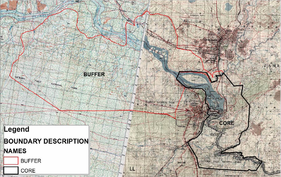
Amended map of the Victoria Falls World Heritage Site submitted as part of the 2016-2021 JIMP. Note the significantly reduced stretch of river corridor (and that the two halves of the map do not even match up correctly, distorting the river). (State Parties, 2016, p.15).
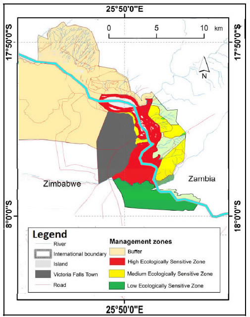
Map of the Victoria Falls World Heritage Site management zones submitted as part of the 2016-2021 JIMP. Note the significantly reduced stretch of river corridor. (State Parties, 2016, p.27).
Management Zone Manipulations
The 2016 plan presented a more detailed text description of the management zonation within WHS (although again omitting the full upstream section of the WHS.
“Modifications to these zones have been made in line with the 1989 World Heritage Bureau recommendations as well as the prevailing inconsistent historic land use. Future modifications can only be made if only they contribute to the enhancement of the OUV.” (State Parties, 2016b, p.26)
The text definitively places the south bank riverine fringe above the Falls as being within the HESZ:
“(i) Highly Ecologically Sensitive Zone (Block 6) - Starting from... the Victoria Falls Bridge, thence north-westwards following the [fenced boundary of VFNP Unit B along the road corridor past the] Victoria Falls Rainforest [entrance, following this boundary round to the turning off of the riverside road known as ‘Zambezi Drive’], thence up the Zambezi River [along the line of the road], covering the riverine vegetation strip to where it joins the Zambezi National Park boundary.” (State Parties, 2016b, p.29)
The description of MESZ confirms the line of this boundary along Zambezi Drive and includes the area extending away from the road and river to the boundary of the VFNP, which here follows the line of the railway loop round to and including the ‘Big Tree’ (Keep Victoria Falls Wild, 2024).
“(ii) Medium Ecologically Sensitive Zone (Block 7) - The zone covers the Victoria Falls border and the Rainforest car park area and continues from the Victoria Falls Rainforest VIP entrance gate, thence along the Zambezi Drive Road to beacon R11, thence westwards following the boundary beacons to where it joints Zambezi National Park boundary.” (State Parties, 2016b, p.29)
The boundary between HESZ (Block 6) and MESZ (Block 7) can therefore be summarised as following the fenced boundary of VFNP Unit B from the Victoria Falls Bridge back to the main visitor entrance and up to the point were Zambezi Drive turns off the main road, then following the line of the road commonly known as ‘Zambezi Drive ’upstream towards the local landmark of the ‘Big Tree’ and thence upstream along the boundary of the Elephant Hills Golf Course. The HESZ therefore covers the Rainforest, upstream covering the riverine fringe between the road and the river and then between the boundary of the Elephant Hills Golf Course and river.
The supporting map correctly shows the boundary of the HESZ initially running along north Zambezi Drive, with the MESZ to the west of the road (area ‘B’ on the annotated map). The area above this, (‘A’) covering the riverside fringe surrounding the Elephant Hills Golf Course, is incorrectly shown as being within MESZ. The lower area, ‘C’ is the transport corridor down to the bridge.
No New Developments
The plan repeats the details of permitted and prohibited developments within the WHS HESZ and MESZ, preventing all new permanent infrastructure in both zones and preventing all new development within the HESZ (the MESZ does allow semi-permanent infrastructure developments).
“5.3.1 Medium Ecologically Sensitive Zone... Prohibited Facilities/Infrastructure: No further permanent structures.” (State Parties, 2016b, p.31-2)
The plan notably also states:
“Future modifications can only be made if only they contribute to the enhancement of the OUV.” (State Parties, 2016b, p.26)
Buffer Zone Removed
The Buffer Zone is significantly amended in the 2016 plan, without explanation or justification, to cover the whole of the wider Zambezi National Park on the south bank, and no longer surrounding the core area of the WHS (the areas of VFNP Areas A and B), with similar amendments on the north bank, removing it from the downstream sections and expanding the upstream area (part of the wider MTNP). The text descriptions within the document are also edited to reflect this change, with the purpose of the zone now specified as:
“This zone is meant to provide for the sustainable management of the natural resources by keeping the environment as natural as possible while enabling medium to large scale development and other activities compatible with conservation principles and objectives of the WHP.” (State Parties 2016b, p.34)
These changes totally negate its purpose in protecting the immediate surrounds of the core area of the WHS. especially where this boundary is also the border of the National Park. The changes effectively negate the Buffer Zone as a management concept - there is no need for it to extend over areas already protected as National Park - and is a dilution of the protections agreed in the 2007 plan. These changes should therefore have been be explicitly rejected by UNESCO.
Carrying Capacity Revised
The 2016 joint management plan indicated a revised carrying capacity of 500 visitors to the south bank and 250 visitors to the north bank at any one time (as opposed to Heath’s 1990 estimate of 250 visitors for each side of the river). The south bank figure is believed to be based on the assumption of an average visit time of one-hour, instead of the widely accepted tourism industry figure of two hours, and effectively doubling the capacity identified in the 1996 IUCN plan (IUCN, 1996).
“Carrying capacity of the Rainforest and Eastern Cataract which currently is set at 500 visitors for the Rainforest and 250 visitors for the Eastern Cataract per any given time.” (State Parties, 2016b, p.42)
Next: Recent Developments
References
Links to external sites or pdf downloads, open in a new window.
State Parties (2016a) State of Conservation Report. Victoria Falls/Mosi-oa-Tunya World Heritage Site. November 2016.
State Parties (2016b) 2016-2021 Victoria Falls/Mosi-oa-Tunya Joint Integrated.
Roberts, P. (2026) Paradise Lost? Conservation and Development of the Victoria Falls (1900-2025). First Edition, February 2026. Zambezi Book Company / CreateSpace Independent Publishing.
UNESCO (2019) Conservation Issues presented to the World Heritage
Committee.
World Heritage Outlook (2020) Conservation Outlook Assessment.