Keep Victoria Falls Wild
Conservation and Development of the Victoria Falls
Early Development of the Victoria Falls
Birth of Livingstone Town
A Valuable Property
Sykes’ Guide to the Falls
The Livingstone Tree
To Be or Not to Be
Livingstone on the Move?
Falls Hotel Rebuilt
Trolley Transport
The following text has been adapted (with permission) from
researched and written by Peter Roberts and published in February 2026
Early Development of the Victoria Falls
Less than fifty years after Livingstone had first set eyes on the Falls, in November 1855, the regions south and north of the Falls had fallen under the control of the British South Africa company, who administered their new territories under a Royal Charter granted by Queen Victoria.
By 1903 it was estimated that about 200 travellers had braved the journey.
“So far, the Victoria Falls have been visited by comparatively few Europeans. Sir Charles Metcalfe, in a recent speech on the railway projects in Rhodesia, stated that since the discovery of the Falls by Livingstone not more than 200 white men had seen the mighty cataract.” (Knight, 1903)
The Chartered Company had been alerted to the need to take action to protect the natural environment of the Falls after it was rumoured in 1894 “that some enterprising individual was going to ‘peg out’ the land around the Falls and charge gate admittance” - an initiative they were keen to forestall.
“The Company wanted ‘immediate action’ to protect the Falls - and particularly its timber resources - from ‘disfigurement at the hands of transport riders, traders and others’ ...A park was designated around the waterfall itself, and a Conservator was appointed... Frank Sykes, who filled this post, was also Civil Commissioner for the Livingstone area.” (McGregor, 2003)
In June 1903 a brick house was being constructed for Mr Sykes at the growing Administrative camp on Constitution Hill. The house, as with his role as Conservator, was jointly funded by the administrations north and south of the river.
“His vision of the Falls was influential, as he designed the modifications of the landscape that made it more amenable to visitors... Sykes felt the landscape needed to be manipulated to ‘excite the wonder of the onlooker’ and to maintain its ‘primitive charm.’ He felt it necessary to ‘open up views of the river by judiciously cutting down trees,’ ‘to fill up gaps by plantations’ and to enlarge hippopotami tracks which were ‘the only means of approach to some of the best points of view.’ He also wanted to charge admission, a proposal that was dismissed by the Company as impractical and ‘undignified.’ Sykes was assisted by a Curator, Mr Allen (Forester to the Rhodesia Railways and former employee of Kew) who was appointed in 1904.” (McGregor, 2003)
The regulations protecting the environment of the Falls not only restricted over-enthusiastic ‘sportsmen’ from shooting animals, but also limited access to the river and Falls for the local Leya people.
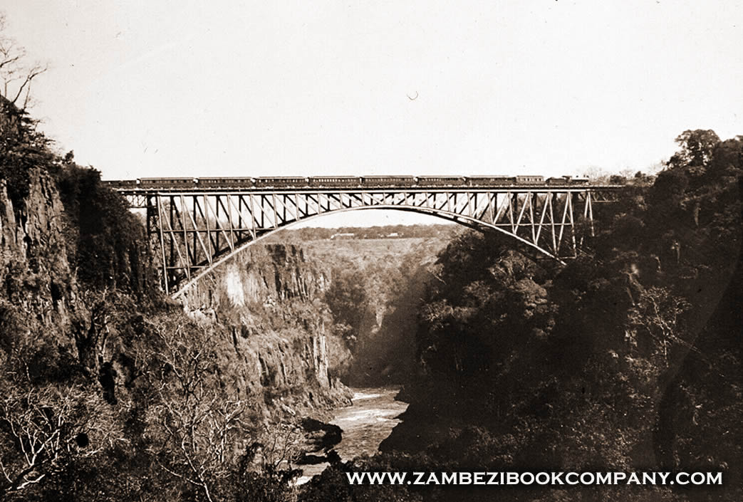
The Falls rapidly fell under the ever increasing sphere of development with the arrival of the railway from the south in mid-1904, construction of the Victoria Falls Hotel (opened June 1904) and Victoria Falls Bridge (opened September 1905).
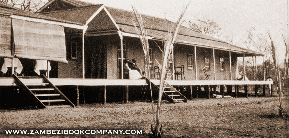
The Falls Hotel was built on land within the designated Railway Reserve, together with the Railway Station, Post Office (with a telegraph line connecting to Livingstone) and Percy Clark’s house and trading huts. All were supplied with water from a small pumping station above the Devil’s Cataract.
News reports in 1905 still referred to the Company’s desire for a much grander Hotel at the Falls, referring to plans for the construction of a ‘mammoth hotel’ (The World’s Work, February 1905). The plans were still being actively promoted in mid-1905, by which time the Hotel’s capacity had been expanded to 80 guests.
“At the Falls themselves there is a Hotel where accommodation is provided for eighty guests. True, it is only a temporary building, but it will shortly be replaced by a permanent one.” (Scientific American Magazine, June 1905)
Birth of Livingstone Town
It soon became apparent that the location of the Bridge and route of the railway would make the Old Drift crossing and settlement, which had grown up at the upstream crossing point above the Falls, redundant - irrelevant of the health concerns of the Administration or the wishes of the settlers. The Chartered Company’s Administration considered two possible resettlement sites along the line of the railway, one that was ‘close to the Falls and the river’ (known as Imbault’s or the Bridge Engineer’s Camp) and the other on the ‘sand-belt some seven miles (11 km) north’ (location of the already established Commissioner’s Camp at Constitution Hill). Without consultation with the settlers, Major (later Sir) Robert Coryndon, the Company’s Administrator for North-Western Rhodesia (1900-1907), decided upon Constitution Hill, where the Government Station and Post Office had already been established, believing that a town “so close to the Falls would be bound to mar the natural beauty of the area” (Phillipson, 1990).
The Old Drift community did not agree with his choice.
“The Old Drifters, however, were opposed to a site so far from the Falls, which they felt would deprive them of the profits of the tourist trade. They proposed instead that the town be situated at the camp of Imbault, the Bridge Engineer, which was on a well-drained site overlooking the river.” (Phillipson, 1990)
Writing at the end of the following year, Moore summarised the settlers arguments against the site chosen by Coryndon.
“Before Livingstone was inhabited, before even it was surveyed, its political history began in the shape of a unanimous expression of popular dissatisfaction with the site selected... The inhabitants pointed out the distance separating the new site from the Falls; its inaccessibility to tourists and others; the distance from the water supply; and the absence of any industry or enterprise in the neighbourhood to justify its existence in the event of its failing to become a resort for visitors. The danger of an opposition township springing up, in a more favourably situated position, on either the South or North bank was urged, and subsequently, the difficulty of constructing roads or of obtaining suitable foundations for brick building in the sandy soil.” (Livingstone Mail, December 1906)
The Administration were unmoved by the arguments of the settlers and planning for the new town continued. Despite plans to hold the auction of plots in late 1904 the Chartered Company finally auctioned 100 stands to the highest bidders on 23rd February 1905 (Baxter and Clay, 1963). To avoid speculation purchasers had to agree to erect on their stands a building to the minimum value of £300 within twelve months. Phillipson later recorded:
“The township itself was laid out as a rectangular gird of streets and sanitary lanes forming fifteen blocks, in all covering an area of rather less than one square kilometre. The central street, Mainway (now Mosi-oa-Tunya Road) was to be forty-three metres wide. The central block was to be an open park, known as the Barotse Centre, which still survives [now renamed Mukuni Park]. The remaining fourteen blocks comprised two hundred and four stands. Some of these were reserved for the Administration’s offices and others for Old Drift residents who were to be forced to abandon their old settlement.” (Phillipson, 1990)
Several months after the auction of plots many members of the Old Drift community were still refusing to swap their cool shaded riverside plots for the sun-baked sand-belt, petitioning for the alternative site closer to the Falls. At the end of June the settlers were instructed in writing by Sykes, as District Commissioner, to cease all trading by 23rd August and depart from the site by 23rd September. The threat of a one pound daily fine from January 1906 finally encouraged the last settlers to move, and in early 1906 the Old Drift was all but abandoned to the bush.
A Valuable Property
The value of the Victoria Falls as a potential tourism destination was soon recognised by the Chartered Company.
“In the Victoria Falls we possess a very valuable property, which is likely to promote materially the prosperity of the country. During the short period in which the railway to the Falls has been open, a large number of visitors has been attracted to them, and the tourist traffic which may be legitimately expected in the immediate future is likely to increase.” (British South Africa Company, 1905)
At the annual General Meeting of the Railway Company shareholders, held in London in 1905, a report was presented recording:
“Lord Grey has told you that we have reached the Victoria Falls. We took over that line on June 20th [1904]... We have also, since then, effected what we call a temporary hotel which, however, is a very comfortable one. It has every modern convenience and accommodation for about forty people. It has most magnificent views of the bluff gorge. It has the electric light, cold storage, hot and cold water baths, and every modern luxury.”
The report also referred to the fragile nature of the Falls environment and concerns over its conservation and preservation.
“We also have a botanist [Mr Allen] who came from Kew Gardens last year. He is looking after the two parks which have been made to preserve the beauty of the Falls from advertisement boards and other buildings, and he is making an arboretum there to grow rare plants.” (Rhodesia Railways, 1905)
The immediate area around the Falls on the south bank, including the Falls Rainforest and extending upstream to the Big Tree and Palm Tree Ferry crossing points, was fenced as part of a conservation plan in 1904.
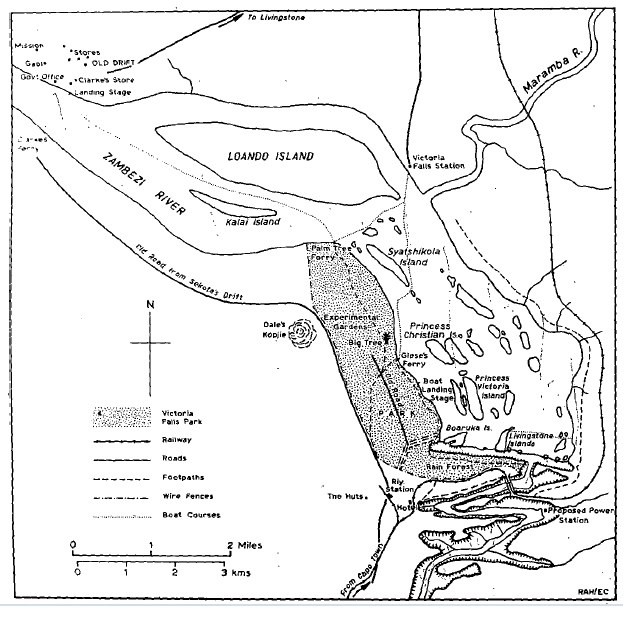
Map showing the boundary of the Victoria Falls Reserve.
(from Heath, 1977)
The area of the Victoria Falls Reserve was formalised in 1906, falling under responsibility of the Lands Department and managed on the ground through the shared role of the Victoria Falls Conservator, Mr Sykes, who was based in Livingstone.
By 1905 it was estimated that some 5,000 visitors had now travelled to view the great waterfall:
“Five thousand people have now seen the Falls, and though that number is a long way off the 500,000 who go to Niagara every year, the ball of information about them has now been well set a rolling by the Chartered Company.” (South Africa Handbook No.34, 1905)
Sykes’ Guide to the Falls
As the Conservator at the Falls, Sykes authored the first ‘official’ tourism guide, published during mid-1905, with the Falls Hotel less than a year old and the Bridge, at the time of writing, complete but awaiting its official opening. Early pathways from the Hotel down to the Bridge, Falls and river are also shown. Sykes introduces his guide with the arrival of Dr Livingstone at the Falls in 1855, and goes on to record interesting local names and their meanings.
“The Native (Sekololo) name for the Falls is Mosi-oa-tunya, meaning ‘the smoke which sounds.’ It is a most appropriate one, as, viewed from any of the surrounding hills, this rising columns of spray, more particularly on a dull day, bear an extraordinary resemblance to the smoke of a distant veldt fire... The native in their songs say ‘how should anyone lose his way with such a land-mark to guide him?’” (Sykes, 1905)
Several features of the Falls had yet to be given their now familiar names, Danger Point being identified as Buttress Point, and the Devil’s Cataract as the Cascade or Leaping Water, so named by Thomas Baines in 1862. The Main Falls, Rainbow Falls and the Eastern Cataract are all identified. Above the Falls Princess Christian and Princes Victoria Islands are named, following their visit in September 1904. Kandahar Island had also been named following the visit of Lord Roberts, also in September 1904.
Cataract Island is given its now commonly used English name, with Boruka Island as “the native name, signifying ‘divider of the waters.’” Of the Rainforest, so named by Edward Mohr in 1870, Sykes notes the “natives themselves refer to it as ‘the place where the rain is born.’”
On Livingstone Island Sykes wrote:
“Situated on the edge of the chasm almost in the centre of the Falls is the Island named after David Livingstone. ‘Kempongo’ was the old native name, which means ‘Goat Island.’ He himself named it Garden Island. It is a curious coincidence that it should bear a similar name to that other island which occupies almost an identical position at Niagara.” (Sykes, 1905)
At the end of the guide Sykes lists the regulations which visitors were expected to follow for the protection of the Falls environments, detailing the prohibiting of:
“- Shooting of any and every description within a radius of five miles [8 km] of the Falls on either bank.
- Netting and dynamiting in the river.
- The cutting of initials on or other defacement of the boles of trees.
- Plucking of flowers and ferns, uprooting ferns, orchids or other plants.
- Setting fire to the grass in the park.
- Trespassing of animals.
- Washing of clothes in the river above the Falls.
- Picnic parties are requested to remove all traces of their presence, such as tins, bottles, paper, etc, before leaving.
“The importance of the above will be obvious to all visitors who are lovers of nature, and their loyal observance is confidently relied upon.” (Sykes, 1905)
The Livingstone Tree
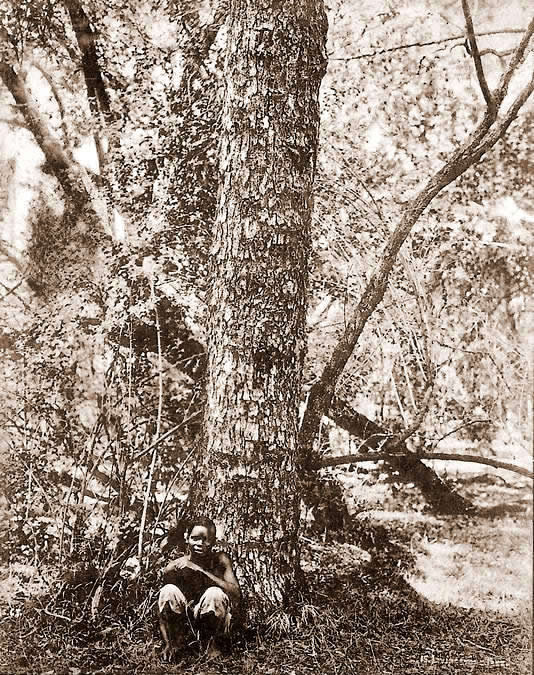
Sykes records interesting details relating to the tree on Livingstone Island upon which Dr David Livingstone had carved his initials in 1855, and which were said to still be faintly visible:
“The Name Tree upon which he cut his initials still remains. Its identity was determined two years ago by the writer... An old white-haired native, by name Namakabwa, who spent most of his time down the gorge catching fish, on being questioned said he well remembered Livingstone, whose native name was ‘Monari,’ coming to the Falls, and described how he (Namakabwa) a day or two after Livingstone’s departure, made his way over to the island and found that a small plot had been cleared of bushes, also that he had made some cutting on a tree. When asked ‘which tree?’ he immediately went to the Name Tree, and put his finger on what had evidently been a cut. The authenticity of the above then is based on the evidence of ‘the oldest inhabitant,’ and may be accepted as genuine. The bark of the tree is so rough and the marks so nearly obliterated that one would have had some doubts on the subject, were the source of information less worthy of belief.
“It is to be recorded with regret that a certain class of tourists, to whom nothing is sacred, had commenced to strip and carry away pieces of the bark from this tree, and so came the necessity for a notice-board and tree-guard, in themselves a witness against the relic hunting vandal who lightly destroys what can never be replaced. Even Livingstone, the discoverer of the Falls, excuses himself for ‘this piece of vanity.’ Would that others were only as sensitive on this point as the great explorer, and delay carving their meaningless initials on the trunks of trees until they can boast such a world-wide fame as was his to excuse the act!” (Sykes, 1905)
To Be or Not to Be
In May 1905 members of the Livingstone community, still dissatisfied with the location of the new town, petitioned the Administration that the Falls Hotel be demolished, arguing that all tourists should be accommodated and served from Livingstone, as had been intended when the railway and town had been originally planned. They also contended that the (then still unpainted) Bridge was a “red monster,” to reach which “an ugly gash had been scoured across the countryside” (Rhodesia Railways Magazine, August 1955).
The Hotel, and indeed Percy Clark, had even been granted trading licenses to run general stores and curio shops on the south bank, causing further consternation, especially when others failed to obtain similar licenses.
The ongoing existence of the Hotel was a significant source of frustration for the Company’s Administrator for North-Western Rhodesia. Coryndon supported the concerns of Livingstone residents and did his best to have the Hotel removed from its site, deploring the positioning of the buildings within sight of the Falls. The Livingstone Mail finally concluded early in 1907:
“[The Administrator] announced that he had failed in his endeavours to have... [the Hotel] abolished. It had originally been erected as temporary accommodation for engineers, etc. employed on the Bridge and Railway construction, and for visitors to the Falls, and was to be pulled down as soon as a new township was laid out; He could hold out no hope of this being done, however.” (Livingstone Mail, January 1907)
To the Company, however, temporary simply meant until they could build bigger and better facilities.
Livingstone on the Move?
Those who had invested in establishing the new town of Livingstone had high expectations of the development which would follow.
“The prospect of the arrival of the railway provoked fantasies of economic growth, and global comparisons. It was confidently assumed that urban and industrial developments would be on the scale of Niagara City and Buffalo, which had grown up on the basis of power generated from the Niagara Falls... The South Africa Handbook of 1903 noted that thanks to the proximity of coal, minerals and water power, the site possessed ‘all the factors for the creation of a great manufacturing centre. A new Chicago, let us call it Cecilton, will spring up near the banks of the Zambezi.’ ... [In contrast] Niagara’s precedent was invoked again in debates over conservation, this time offering a negative example. Lord Curzon was not alone in feeling that the Victoria Falls were more sublime than Niagara on the grounds of the ‘lack of signs of civilization,’ and it was widely believed that new industrial prosperity in Niagara had spoilt its aesthetic appeal.” (McGregor, 2009)
But industry, and tourism, was slow to reach Livingstone and residents in their dissatisfaction blamed the Chartered Company. Moore voiced his varied criticisms against the Company and its Administration through the pages of the Livingstone Mail, identifying the poor transport links between Livingstone and the Falls as a significant handicap to tourism.
“Conductor Holland informs us that there were 101 passengers on board last Saturday’s train de luxe. About a dozen of them managed to get as far as Livingstone. This is most unsatisfactory and it is to be hoped that some effort will be made... to provide transport facilities for our visitors.” (Livingstone Mail, April 1906).
By August 1906 rumours were in circulation concerning the ongoing campaign by the residents, led by Moore and the Livingstone Mail, to relocate Livingstone to a site closer to the Falls. It was believed that the Administration had requested £60,000 in order to move both the capital at Kalomo and the town of Livingstone to a new site in the vicinity of the abandoned Bridge Engineers Camp. A front-page headline from the Livingstone Mail in June 1907 claiming that the move had finally been approved turned out to be wishful thinking.
In August 1907 three of the Directors of the Board of the Chartered Company, Henry William Montague Paulet (the 16th Marquess of Winchester), Sir John Henry Birchenough (later to become President of the Company) and Mr Henry Wilson Fox, visited to review the proposals regarding the capital and address the concerns of the residents of Livingstone, who at that time numbered some 180 individuals.
Sir Birchenough apparently felt that Livingstone should be relocated to the present site of the Victoria Falls town on the south bank. The other two representatives were initially in favour of a move to a new site on the north bank. In the end, however, they decided only to relocate the capital from Kalomo to Livingstone, and left to the residents to decide whether to stay in Livingstone or to move to the south bank, where the development of a small settlement was now officially accepted.
Livingstone became the capital of North-Western Rhodesia in September 1907, bringing at least some life, and trade, to the struggling township. The town remained the capital after the formation of Northern Rhodesia in 1911 (following the amalgamation of the territories of North-Eastern and North-Western Rhodesia) up until 1935 when the administration was moved to Lusaka, the current capital.
During 1908 surveys and plans on the south bank resulted in proposed layout for the new township.
"The earliest available plan of the village is that representing the survey carried out by P. Fletcher in March 1908 (Fig. 2). This shows 147 stands, laid out in a rectangular grid pattern, which were intended to form the nucleus of the township. Fletcher’s plan also indicates the Railway Reserve where, until that date, all development had taken place. As well as the railway and hotel buildings, a post office with a telegraph line to Livingstone, Zeederberg’s transport depot and Percy Clark’s house and curio shop were all located within the Railway Reserve and were supplied with water from a small pumping station above the Devil’s Cataract, as well as electricity. The plan also shows that in 1908 the railway line to Livingstone passed to the east of the Victoria Falls Hotel in a shallow cutting, part of which remains visible today." (Heath, 1977)
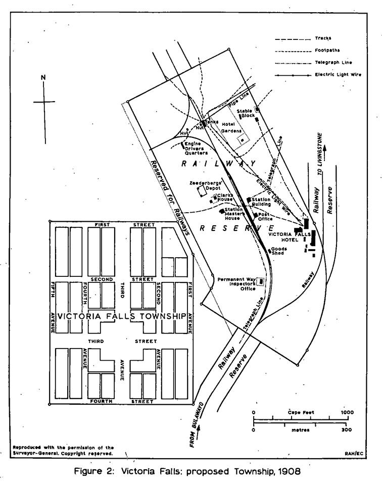
1908 Victoria Falls Town Plan showing existing development within the Railway Reserve and the proposed layout for the new town
(from Heath, 1977)
Despite the commitment to develop a settlement on the south bank it was announced in 1909 that the project had been abandoned for the foreseeable future.
“The project for establishing a township at Victoria Falls has been temporarily abandoned, and it seems to us unlikely that it will be revived while the Company retains the administration.” (Livingstone Mail, December 1909)
Falls Hotel Rebuilt
By 1912 plans were well advanced for the redevelopment of the Falls Hotel. Having secured the future of the Hotel on the site, the Railway Company now planned to expand and erect permanent brick buildings. Preliminary drawings were supplied by Sir Charles Metcalfe but the final designs, dated April 1912, were executed by Bulawayo based architect Frank Scott.
The new buildings were constructed from 1914, with completion of the work postponed by several years due to the impacts of the First World War. The final furnishing and fitting further delayed the opening of the new Hotel until mid-1917, at an approximate construction cost of £40,000.
The cool and spacious single-storey building, consisting of a central wing and two flanking side wings, housed twenty-four bedrooms and two private suites. Two observation towers, either side of the main wing, gave panoramic views over the gorges to the Bridge and rising spray of the Falls. Guests could relax in the Lounge, find time for quiet reflection in the Writing Room, or socialise in the Drawing and Music Rooms, Smoking Room or small private bar. A darkroom was provided for the use of amateur photographers. The spacious new Dining Room was designed with echoes of features from the original railway shed which had served as the Hotel’s first dining room, an example being the high oval windows, also a feature of the Lounge. Another short wing housed the Hotel’s kitchens.
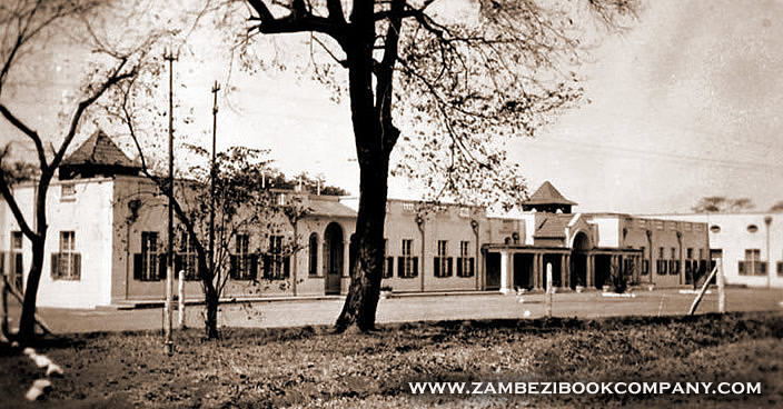
Victoria Falls Hotel (c.1917).
(Image credit:
Zambezi Book Company)
Trolley Transport
The local rail trolley system was developed by the Railway Company in 1920, at a cost of £4,000, with the operation of the service managed by the Hotel.
“The trolley system had three sections, not physically connected. From the hotel, a double track ran one mile northward to ‘Trolley Junction,’ where passengers changed to two single track lines leading to the various points of interest. One line (the longest) ran eastward beside the Rain Forest to the Victoria Falls Bridge, and was later paralleled by a road; the other ran northward to the Landing Stage and Boat House... From the terminus of this line, three-quarters of a mile upstream from the Falls, tourists could join launch or canoe trips to the islands in the river. Photographs show two types of vehicle, a four-seat trolley with cross seats pushed by two Africans, and a knifeboard eight-seat trolley pushed by three or four. Each trolley had a roof and canvas awning, and a screw handbrake applied from either end.” (Price, 1966)
Telephone boxes were installed at each terminus and junction so that a trolley could be summoned when required. The fare was one shilling each way. The trolleys were available during the hours of daylight only, although special arrangements could also be made with the Hotel Manager each month on the full-moon for night-time trips to see the lunar rainbow.
The Hotel also purchased a launch boat, the ‘Diana’, carrying up to 30 passengers. Two huts and a boat shelter were developed on the riverside at the launch site, a short distance upstream of the Falls. The Hotel also invested in four canoes. The trips operated upstream to Kandahar Island, where passengers would alight for a picnic.
Later, in 1928, the Hotel invested in a second launch, the ‘Daphne’, carrying up to 35, and soon after a third, the ‘Dorothy,’ carrying 10 passengers. A launchway was developed at the landing stage in 1928, and shelters built for the launches in 1938.
The Falls Hotel was significantly expanded during the late 1920s and early 1930s, with the addition of the ‘hammerheads,’ courtyard and western wings, which even included a small chapel. The redevelopment of the Hotel buildings created the foundations of the Hotel as we know it today.
Next: Protection and Preservation
References
Links to external sites or pdf downloads, open in a new window.
Baxter, T. W. and Clay, G. (1963) The Discovery And Historical Associations [In Fagan, B. M. [Editor] (1963), Chapter 1.]
British South Africa Company (1905) Annual Report.
Heath, R. A. (1977) Victoria Falls. The Growth of a Rhodesian Village Proceedings of the Geographical Association of Rhodesia. No.10, p.15-29. [pdf]
Knight, E. F. (1903) South Africa after the War, A Narrative of Recent Travel. Longmans, Green and Co, London.
Livingstone Mail (April 1906) 21st April. No.3 (Quoted in Arrington, 2010).
Livingstone Mail (December 1906) Livingstone in 1906 - A Retrospect. Christmas Edition.
Livingstone Mail (January 1907) Meeting with His Honour the Administrator. 19th January. No.43.
Livingstone Mail (December 1909) Our Annual Retrospect. Christmas Edition.
McGregor, J. (2003) The Victoria Falls 1900-1940: Landscape, Tourism and the Geographical Imagination, Journal of Southern African Studies, Volume 29, Number 3, September 2003, p.717-737. [pdf]
McGregor, J. (2009) Crossing the Zambezi : The Politics of Landscape on an African Frontier.
Phillipson, D. W. (1990) The Early History of the Town of Livingstone, in Phillipson D. W. [Editor] (1990) Mosi-oa-Tunya: a handbook to the Victoria Falls region. Salisbury: Longman, Zimbabwe. (First published 1975, Second edition 1990)
Rhodesia Railways (1905) Minutes of Ordinary General Meeting.
Rhodesia Railways Magazine (August 1955) Fifty Years - The Story of a Bridge (Part 2). Vol.4, No.3, p.21-23.
Roberts, P. (2025) Footsteps Through Time - A History of Travel and Tourism to the Victoria Falls. Second Edition. Zambezi Book Company / CreateSpace Independent Publishing. (First published 2017, fourth edition July 2025).
Roberts, P. (2026) Paradise Lost? Conservation and Development of the Victoria Falls (1900-2025). First Edition, February 2026. Zambezi Book Company / CreateSpace Independent Publishing.
Scientific American Magazine (1905) Completion of the Victoria Falls Bridge. 22nd July, 1905, p.68-69.
South Africa Handbook No.34 (1905) A Trip to the Victoria Falls and Rhodesia. Winchester House, London.
Sykes, F. W. (1905) Official Guide to the Victoria Falls. Bulawayo.
The Worlds Work (February 1905). Among the World’s Wonders. Vol.9 No.4,
p.5879.