Keep Victoria Falls Wild
Conservation and Development of the Victoria Falls
Protection and Preservation
Power from the Falls
The Price of Paradise
Victoria Falls National Park
Victoria Falls Trust
Increasing Numbers
Special Area Reduced
Mosi-oa-Tunya National Park
The following text has been adapted (with permission) from
researched and written by Peter Roberts and published in February 2026
Protection and Preservation
The Victoria Falls Executive Committee was established on the north bank in 1934 under the Victoria Falls Reserve Preservation Ordinance, with the primary objective to foster tourism. Developments in 1935 included the first chalets at the North Bank Rest Camp and establishment of the Livingstone Game Park, located on the downstream side of the Maramba River just above the Falls (and later relocated further upstream and incorporated within the Mosi-oa-Tunya National Park).
On the south bank the Victoria Falls Reserve Preservation Act (1928) had been drawn up establishing the Victoria Falls Reserve, covering the area within a five-mile perimeter of the Falls. In 1931 the upstream Victoria Falls Game Reserve was established under the Game and Fish Preservation Act (1929), later to become the Zambezi National Park.
“In 1931 the Victoria Falls was declared a ‘protected area’ and the use of the environs of the Falls became more strictly controlled... In 1932... the piped water supply was extended to the Police Camp and to the remainder of the village in the following year. To the north of the curator’s cottage... five stands had been occupied by Messrs. Spencer, Gibson and Lloyd, and further north, by a Mr J Picken. It was decided to accept the status quo and to re-plan the township incorporating these five stands, the curator’s cottage and the police camp... Little major development took place between 1930 to 1939.” (Heath, 1977)
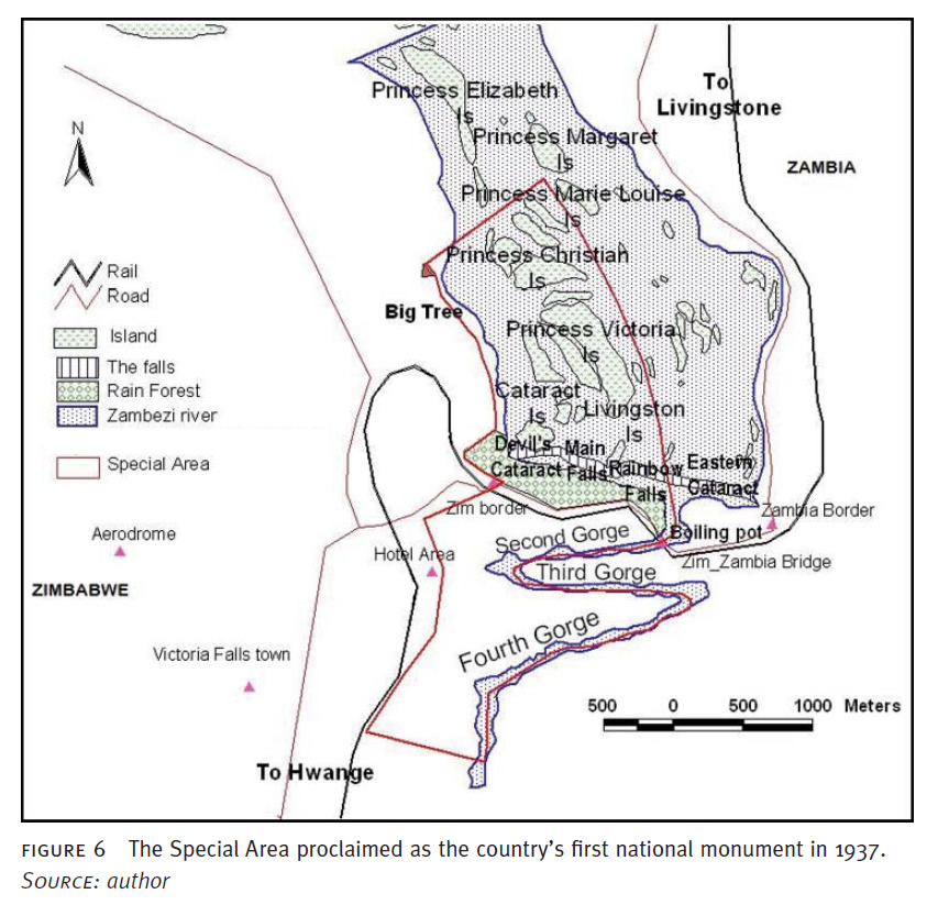
The Victoria Falls Special Area, a zone extending upstream and downstream of the Falls, was proclaimed the counrty's first National Monument by Government Notice No.318 on the 14th May 1937, under the Southern Rhodesia Monuments and Relics Act (1936), which also repealed the 1928 Victoria Falls Reserve Preservation Act. Government Notice No.317 approved the bylaws which were to be enforced within the protected area, which now fell under the control of the Commission for the Preservation of Natural and Historical Monuments and Relics.
The Victoria Falls 'Big Tree,' the large baobab (estimated to be over 1,200 years old) which was the meeting place for early travellers to the Falls, and which also had a spirtual significance to local people, was proclaimed a National Monument on 10th March 1939 (later deproclaimed).
Power from the Falls
The Chartered Company had originally sold the contract to develop the hydro-electric potential of the Zambezi in the vicinity of the Victoria Falls in 1901 as a key part of the initial development of the region, but the project was not finally realised until the late 1930s.
Located in the bend of the third and forth gorges, known as the Silent Pool, construction of the plant was begun in June 1936 by the Victoria Falls and Transvaal Power Company. The Power Station was opened on 16th March 1938 by Sir Hubert Young, then Governor of Northern Rhodesia. The immediate scope of the scheme was to supply electricity to the neighbouring town of Livingstone, with power transmitted by underground cable, as well as serving the Falls Hotel and Railway Reserve on the south bank.
“At the request of the Government great care was taken to avoid spoiling the beauty of the Falls. The water inlet is some distance above the Falls and an underground pipe-line leads to the top of a gorge some distance below them. An overhead power cable was necessary in one place [to cross the gorge and serve the Hotel], but it was put as far from the Falls as possible and it will not be seen by tourists. Even in the dry season the quantity of water taken by the Power Station is negligible in comparison with the total flow over the Falls.” (Parsons, 1938)
During a period of excessive drought in the late 1940s it was reported that engineers were actively blasting rock from the river bed in order to divert additional flow to the power station.
“Denied water by a series of drought years near the source of the Zambesi (in the Belgian Congo), Dr David Livingstone’s famous Victoria Falls have been at their ‘lowest in living memory’ this African summer... Rhodesian engineers have for weeks been blasting the bed of the crocodile and hippo-inhabited river above the Falls to force a sufficient flow of water to turn the dynamos.” (The Sydney Sun, December 1949)
In 1949 the then Northern Rhodesian Government acquired all interests in the Power Company for the sum of £104,000. The original capacity of 8 Megawatts (MW) was expanded in 1969 with the addition of six generators of 10 MW each (installed underground) and again in 1972 with an additional four units, increasing the total maximum capacity to 108 MW. The expansions and subsequent plant developments have significantly increased the infrastructure impacts both above and below the Falls, as well as increasing the volume of water diverted from the Eastern Cataract of the Falls.
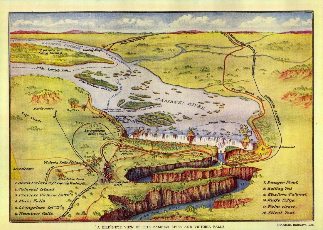
1930s map of the Falls area.
The Price of Paradise
The development of the Falls as a global tourism resort resulted in a steady process of eviction and exclusion of Africans from the immediate region of the Falls and the river, as evidenced on the southern bank during the establishment of the Victoria Falls Game Reserve.
“The process of physical exclusion was most dramatic and most total on the south bank, from which the Leya population was completely removed between 1900 and 1940... The Leya on the south bank had initially been encouraged to move across the river to the north bank on their own accord, as taxes were more onerous and were implemented earlier south of the river. Evictions gathered pace in the 1920s and the last vestiges of Leya settlement on the south bank were totally cleared in the 1930s, when the Administration ordered them to ‘return home’ to the north bank, from which officials held they originated... Those who tried to resist were forced out by threats and the burning of their homes...”
“The former Leya inhabitants are still remembered in place names in the Victoria Falls National Park. Jafuta, for example, was an important Leya man who lived in what became the Park, and his name still appears on signposts to the luxury ‘Jafuta Lodge.’ He farmed a fertile vlei just south of the Falls at Chamawondo and owned a canoe and a sizeable herd of cattle. The village he headed was split by the evictions, some members went to Zambia as the state instructed, others moved onto the infertile lands of the increasingly crowded Hwange native reserve to the east and south of the Falls.” (McGregor, 2003)
Mubitana (1990) also records Leya presence on both sides of the river into the early 1930s, confirmed in a report by J Moffat Thomson, Secretary of Native Affairs in Northern Rhodesia. McGregor reflects in contemporary interviews:
“Old people claim there were several rounds of evictions starting in the 1920s and continuing in the 1930s and 1940s. This seems plausible, although the archival record is scant, even at the height of the evictions in the 1930s. In 1935 the Native Commissioner Wankie noted: ‘Most of the natives who resided in the Victoria Falls Game Reserve were removed in July to Northern Rhodesia’; in 1936 removing people ‘from whence they came’ is reported as almost completed; in 1937, a further 41 people were sent back to Northern Rhodesia...
“Africans remaining in the vicinity of the Falls on the south bank in the wake of the 1930s evictions - most of whom were working at the resort itself and who included many Leya and Lozi - were ‘removed to a central village away from the river’ in 1940...
“On the north bank, land alienation was also severe, and evictions also proceeded apace as Livingstone town grew, and as farms were pegged out along the river frontage and the line of rail, and as other prime sites for tourist development were reserved as crown land. Mukuni and Sekute’s people were forced into the Leya and Toka reserves respectively, along with others, where soils were poor and where they lacked access to the river for gardens, fishing and grazing cattle. The justification for these restrictions was that African settlement and land use spoilt the view and undermined the area’s tourist potential.” (McGregor, 2003)
In 1947, Southern Rhodesia recorded over 38,000 tourist arrivals. By contrast, Northern Rhodesia received less than half this number, recording only 15,000 visitor arrivals.
During the 1948-49 financial year (to end June) the Victoria Falls Hotel recorded record guest arrivals totalling 21,014 and representing 49,707 bed-nights. For the operational year ending March 1950 the Hotel recorded another record of 21,052 guests.
Victoria Falls National Park
Changes on the south bank in 1952 amalgamated the Victoria Falls Reserve immediately around the Falls, with the larger Victoria Falls Game Reserve, covering an area upstream of the Falls, to form the wider Victoria Falls National Park under Proclamation 25 (1952) of the National Parks Act (1949). The protected area covered 57,000 hectares, with the town of Victoria Falls an excluded enclave, surrounded by the National Park. Management of the Victoria Falls Special Area, including the river sections immediately above and below the Falls, had been transferred over from the Commission for the Preservation of Natural and Historical Monuments and Relics to the National Park Advisory Board (N.P.A.B.) the previous year.
“In 1949, the National Parks Advisory Board (N.P.A.B.) was constituted... As a first step towards relieving the Commission of the burden of administering tourist visitation to monuments, an arrangement was made for the N.P.A.B. to take over the management of Victoria Falls... on 1 April 1951... From this arrangement, the Special Area... assumed dual custodianship protected by both the Commission and the N.P.A.B.” (Makuvaza, 2012)
Tourism infrastructure and services on the south bank were developed, including the centrally-located Rest (or Main) Camp and the upstream Zambezi Camp, providing flexible accommodation options for independent travellers.
“On the Southern Rhodesian bank, where a National Park has been established, there are two Rest Camps - Main Camp, which is close to the Victoria Falls village, and the Zambesi Camp, which is situated four miles [6.5 km] up river in shady surroundings and commanding magnificent views of the river and islands. The Zambesi Camp consists of a single building with a number of large double rooms, comfortably furnished, and with adequate bathing and sanitary arrangements...
“The huts at Main Camp are substantially built and comfortably furnished with beds, mattresses, chairs, table and toilet set. Each bed is fitted with a mosquito net and the windows are curtained and mosquito-proofed. Bedding is provided at the option of the visitor. Crockery and cutlery may be hired from the Falls Supply Store, where a full range of groceries is also stocked... Charges at Main Camp are 5s per day if no bedding is ordered and 6s per person per day with bedding. At Zambesi Camp the charge is 7s 6d per person per day with bedding. Double and family huts are available at Main Camp.” (Southern Rhodesia Public Relations Department, c1955)
The Zambezi Camp offices and self-catering chalet facilities incorporated the abandoned B.O.A.C. buildings at the Jungle Junction.
“The Zambezi Camp which is on the river bank was erected as offices and a staff residence for the B.O.A.C. during the time when flying boats were used on the London-Johannesburg flight. Holidaymakers not wishing to do their own catering will find the Impala Inn is very close to the Southern Rhodesian Rest Camp and the Falls Restaurant is only across the road from the Northern Rhodesian Rest Camp. For those people who prefer to sleep under canvas or use their own caravans, there are camping sites equipped with ablution and sanitary blocks near both the rest camps. Tents and marquees can be hired at the northern bank camping site.” (Woods, 1960)
A riverside drive was established running upstream along the scenic stretches of the Zambezi that had so enchanted Livingstone.
“The main road in the Park is a gravel road and it has not been possible up to 1959 to make this an all-weather road, so during the rainy season this part of the park has unfortunately to be closed... Another 50 miles [80.4 km] of loop roads were under construction in 1959 and these will give access to the country further away from the river and so open up new areas for the sightseer.” (Woods, 1960)
The centrally located main Rest Camp would quickly grow to offer 30 self-catering chalets, caravan park and camping, set amongst shaded gardens and fine native trees. Increased tourism levels brought further development to the small town, with private stands and stores providing accommodation and services for the growing numbers of professional staff based at the Falls.
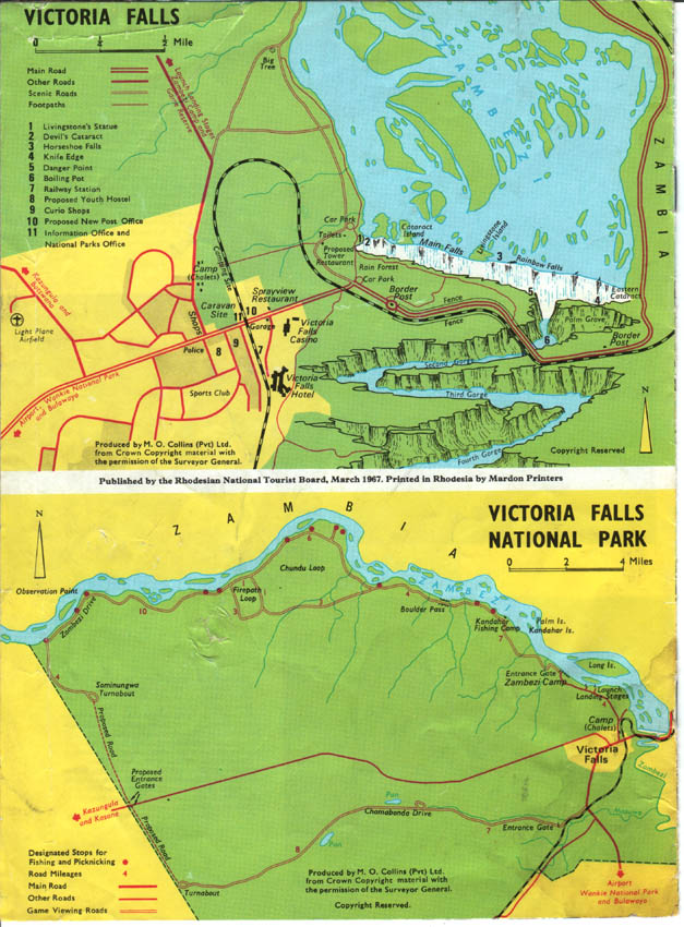
Map showing the Victoria Falls National Park and town enclave.
Victoria Falls Trust
Another significant development on the northern bank was the formation of the Victoria Falls Trust, to oversee the preservation of the physical environment of the Falls from ecological damage and to encourage tourism, on 15th March 1954. Trustees were selected from the local Livingstone community and appointed by the Governor of Northern Rhodesia.
The wider area was de-gazetted as a National Monument but several smaller archaeological sites within the reserve were declared as National Monuments. The Historic Monument Commission continued to oversee the conservation and management of the Falls whilst the Trust concentrated on tourism management.
The work of the Trust included overseeing the development and management of Rest Camp and Camping Site tourism facilities on the north bank of the river above the Falls, which now offered 36 self-catering chalets for visitors.
“The Rest Huts in this Camp are equipped with electric light and adequate furniture, with separate bathrooms and outside fireplaces for cooking. Accommodation costs 3s per person per day (children under 12, 1s 6d) but tenants are expected to supply their own food and cooking utensils. Bedding is supplied, if required, at an extra charge of 2s 6d for the first night and 1s per night thereafter. A tearoom [which became known by locals as ‘Chippy Woods’]... is open until 10 p.m. where full meals are served and tinned goods stocked, is situated near the camp. It is advisable to book bungalows in advance, especially from May to August and over the Easter, Christmas and Rhodes and Founders holiday periods.” (Southern Rhodesia Public Relations Department, c1955)
In addition the Trust oversaw the development of tourism attractions such as the Maramba Cultural Village and the Livingstone Zoological Park (later the Mosi-oa-Tunya National Park), opened in 1955. The period saw rising tourism arrivals to the region, with 43,000 arrivals recorded for Livingstone in 1955 and over 47,000 in 1956, a fifty percent increase since 1953 (Economic Survey of Livingstone, 1957).
Increasing Numbers
The 1962 census recorded the population of Victoria Falls town as 1,601 (Central Statistics Office, 1964).
By 1969 the population of Victoria Falls town had grown to 3,450 (Central Statistics Office, 1969).
The population of Livingstone was recorded at 49,063 in the census of 1969.
Zimbabwe national annual tourism arrivals reached 270,000 in 1970, up from 250,000 the previous year. Arrivals peaked at 360,000 in 1972.
"The steadily increasing numbers of tourist arrivals to the country was not initially disrupted by Rhodesia’s unilateral declaration of independence (UDI) in 1965 and the imposition of mandatory United Nations sanctions (Figure 1). After 1972, this growth faltered in response to the intensification of the war which preceded Zimbabwe’s independence in 1980 and which mainly affected the rural areas in which most parks and reserves are located. The immediate effects of the war probably masked the influences on local tourism which would have been expected from the downturn in tine global economy in the mid-1970s." (Child, Heath and Moore, 1989)
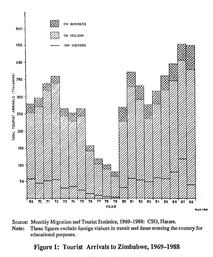
Tourist Arrivals to Zimbabwe, 1969-1988
(from Child, Heath and Moore, 1989)
In 1973 the town was estimated to cover 310 hectares (PlanAfric, 2001). Heath records the population of Victoria Falls Town in the mid-1970s at around 3,000, and highlighted the increasing tourism pressures during the 1970s.
“The rapid growth of Victoria Falls during the last decade has caused considerable planning problems. It is of paramount importance that the immediate vicinity of the Falls should be altered as little as possible if its natural qualities are to be preserved. Conservation needs, however, may conflict with the need to provide facilities for tourists and in recent years there has been a proliferation of tourist services along the river bank upstream from the Falls.” (Heath, 1977)
Special Area Reduced
Increasing development pressures resulted in the decision to reduce to size of the south-bank Special Area to concentrate on the core area around the Falls, including the Rain Forest, the river, islands and riverine fringe upstream as far as the ‘Big Tree’ and the downstream gorges as far as the fifth gorge.
“In order to preserve the beauty of the natural and cultural surroundings of the site, the Commission [for the Preservation of Natural and Historical Monuments and Relics] made a decision in 1968 to reduce the size of the original boundaries of the Special Area. Accordingly, in order to change the boundaries of the national monument, the original site was de-proclaimed as a national monument, cancelling the previous Government Notices no.318 of 1937, no.922 of 1947 and no.453 of 1970. A smaller area was re-proclaimed [under of the Monuments and Relics Act] as a national monument by Government Notice 640 of 1970.” (Makuvaza, 2012)
Map showing the revised boundary of the Victoria Falls Special Area.
In proclaiming the new boundaries of the protected area it was stressed that no buildings other than those already agreed could be erected and that the area must remain undeveloped except for work to prevent soil erosion and the destruction of indigenous trees and other vegetation (Makuvaza, 2012).
The National Museums and Monuments Act 1972 amalgamated the Commission for the Preservation of Natural and Historical Monuments and Relics with the National Museums of Rhodesia, to establish the National Museums and Monuments of Rhodesia (NMMR, later to become National Museums and Monuments of Zimbabwe).
Mosi-oa-Tunya National Park
On the north bank the Victoria Falls Trust was dissolved and the Zoological Game Park redesignated as the expanded Mosi-oa-Tunya National Park on 25th February 1972, managed by the National Parks and Wildlife Services (now the Zambia Wildlife Authority). The Natural Heritage Commission (now the National Heritage Conservation Commission) continued to manage the Falls and historic cultural sites within the National Park, including the Old Drift settlement.
Next: Development of the Falls
References
Links to external sites or pdf downloads, open in a new window.
Central Statistics Office (1964) Final Report of the April/May 1962 Census of Africans in Southern Rhodesia, Central Statistics Office, Salisbury.
Central Statistics Office (1969) Census Report, Central Statistics Office, Salisbury.
Child, Heath and Moore (1989) Tourism to National Parks in Zimbabwe 1969-1989. Proceedings of the Geographical Association of Rhodesia. No.20, p53-78. [pdf]
Economic Survey of Livingstone (1957) Rhodesia and Nyasaland Prime Minister’s Department.
Heath, R. A. (1977) Victoria Falls. The Growth of a Rhodesian Village Proceedings of the Geographical Association of Rhodesia. No.10, p.15-29. [pdf]
Makuvaza, S. (2012) Who Owns the Special Area at Victoria Falls World Heritage Site? The Historic Environment, Vol.3 No.1, April, p42-63. [pdf]
McGregor, J. (2003) The Victoria Falls 1900-1940: Landscape, Tourism and the Geographical Imagination, Journal of Southern African Studies, Volume 29, Number 3, September 2003, p.717-737. [pdf]
Parsons, D. (1938) Harnessing the Victoria Falls. Discovery.
PlanAfric (2001) Victoria Falls Combination Master Plan, Victoria Falls Combination Master Plan Preparation Authority. Bulawayo.
Roberts, P. (2025) Footsteps Through Time - A History of Travel and Tourism to the Victoria Falls. Second Edition. Zambezi Book Company / CreateSpace Independent Publishing. (First published 2017, fourth edition July 2025).
Roberts, P. (2026) Paradise Lost? Conservation and Development of the Victoria Falls (1900-2025). First Edition, February 2026. Zambezi Book Company / CreateSpace Independent Publishing.
Southern Rhodesia Public Relations Department (c1955) Victoria Falls, Greatest River Wonder of the World. Public Relations Department of Southern Rhodesia.
The Sydney Sun (December 1949) Victoria Falls are almost dehydrated. 27th December. [Online source: https://trove.nla.gov.au/newspaper/article/230741817]
Woods, J. (1960) Guide book to the Victoria Falls. S. Manning.