Keep Victoria Falls Wild
Conservation and Development of the Victoria Falls
The 2024 National Park Management Plan
Stakeholder Concerns
Boundaries Clarified
Zones Confirmed
‘Green Belt’
Riverside Camps
River Jetty Issues
Island Intrusions
Helicopters and Helipads
Council Expansion
Carrying Capacity Concerns
The following text has been adapted (with permission) from
researched and written by Peter Roberts and published in February 2026
The 2024 Park Management Plan
A new ten-year Zambezi/Victoria Falls National Park General Management Plan (2024-2034), dated October 2023, was approved in April 2024 (Zimbabwe Parks and Wildlife Management Authority, 2024). The Plan presents a new map clarifying the World Heritage Site boundary and management zones, due to be presented in the new Joint Integrated Management Plan for the Victoria Falls World Heritage Site (and which itself was initially due for submission to UNESCO by the end of June 2024, extended to mid-2025).
The draft ZNP/VFNP Management Plan, circulated in November 2022, identifies the forested riverine fringe as being particularly at risk from tourism developments, the river, islands and gorges, together with the springs and drainage lines which flow into the river, being under very high risk from development (ZPWMA, November 2022, p.19).
Stakeholder Concerns
The Plan identified tourism pressures as the most immediate and and also long-term threat to the Victoria Falls and World Heritage Site designation.
“The threat from tourism pressure and the related activities is the most immediate and long-term of those facing the Falls and its endurance as a WHS and desired destination.” (ZPWMA, 2024, p.17)
A summary of stakeholder concerns highlighted maintenance of wildlife corridors and over-development among several key issues:
“Some of the main concerns mentioned by stakeholders include the following:
1. Lack of transparency and public process in issuing many of the recent leases
2. Exclusive leases alienating the river front and public access
3. Inappropriate siting of leases - no plan
4. Degradation of the tourism product in the Zambezi National Park though proliferation of camps near entrance
5. No buffer for developments around Rain Forest.” (ZPWMA, 2024, p.60)
Particular concerns were raised over the preservation of wildlife movement corridors and over-development of natural areas.
“Corridors and wildlife access are an issue in the landscape. At the local level the extent of development blocks access to the Zambezi River (and to crossing points for elephants). In the wider landscape fencing has the effect of changing movement patterns of wildlife, sometimes with unintended consequences (e.g. increased human-wildlife conflict...
“There are concerns about over-development of the resource with a proliferation of lodges, hotels and activities in areas adjacent to the Falls and in the World Heritage Site. There also concerns about the standard and validity of environmental impact assessments that support these developments. Not enough attention is being paid to the conservation of the natural environment which is one of the drawcards for the tourism industry In the area.” (ZPWMA, 2024, p.38)
Concerns were also expressed over tourism development concessions and leases and their growing impact on the tourist experience.
“The issuing of riverfront concessions both in the VFCC area and the parks estate has proliferated in recent years and continues without any due regard for planning or the environment. There are concerns that the WHS ‘red zone’ has been eroded by these developments and leases. Concern was expressed about lack of transparency in tender, EIA processes and lease terms and conditions...
“There is a perception that the tourist experience in the Falls and the Zambezi National Park is being degraded through helicopter noise, lack of river access, restricted access in the Park itself due to the road network, developments proposed in sight of the rainforest (both in Zambia and Zimbabwe). Concerns were also expressed about inappropriate location of curio vendors at the Big Tree and inside the Rainforest.” (ZPWMA, 2024, p.60)
Boundaries Clarified
The Plan confirmed the area Victoria Falls National Park as being 3,050 hectares (30.5 km²) and extends 17 km downstream (in addition to 6 kilometres of the upper river). This is in contrast to the previously recorded figure of 2,340 ha and is believed to be explained by the area of the river not being included in the original calculation. A later note indicates that the park includes approximately 11 km² of river and islands (ZPWMA, 2024, p.12).
“The Victoria Falls National Park is the smallest in the country with an estimated area from the mapping data of 30.5 km² with 17 km of gorges below the Falls. Divided into Victoria Falls A and B and contains parts of the upper river, the Victoria Falls, the rainforest and the downstream gorges.” (ZPWMA, 2024, p.4)
The Zambezi National Park is calculated at 530 km² and includes approximately 18 km² of river and islands. The revised figures indicate that the area of the World Heritage Site is currently incorrectly recorded.
Zones Confirmed
The map confirms upstream riverside fringe as being in the red zone Highly Ecologically Sensitive Zone (HESZ) which prevents all new development (Zimbabwe Independent, 16th August 2024). For the last few years Park Authorities have claimed this area was part of the Medium ESZ (MESZ) and which therefore allowed suitable tourism development.
“A key issue put forward by stakeholders is the lack of transparency about lease ownership, boundaries, tenure and income to ZPWMA. Given that these areas are national assets this information should be publically accessible and this will, in the long-term, ensure that income to the ZPWMA is maximised and that assets are not undervalued.
“There are at least two leases that are wholly or partially in the red zone of the World Heritage Site as it is described in the most recent Joint Integrated Management Plan - The Tree Lodge (in front of the Elephant Hills Golf Course) and a restaurant approximately 50 metres from the lip of the Devil’s Cataract. The description for inclusion in the red zone reads ‘the riverine fringe between the Rain Forest and the Zambezi NP’ and both of these developments are clearly in that zone. One of these developments (the restaurant) is currently in the courts but building continues. These issues need to be resolved as soon as possible.” (ZPWMA, 2024, p.69)
Tourism developments within the UNESCO World Heritage Site 'HESZ' or 'red zone' include the Baines Restaurant (opened in mid-2023), Zambezi Drive ‘Rock Pool’ bar (also established during 2023), both along the riverine fringe immediately upstream the Falls, the proposed Riverside Tree Lodge and the upstream Kandahar Camp development where concession agreements have been again been approved by Parks in areas supposedly protected under the HESZ. The area of all these developments is identified in the 2007 and 2016 JIMP documents as being within the HESZ (State Parties, 2007; 2016). According to the new map, and presumably new JIMP, the area remains in the HESZ.
The Plan also hinted at the rational for the ‘Rock Pool’ development, without detailed explanation:
“The ZPWMA has established the ‘Rock Pool’ social area a few hundred metres above the Falls. This is to give local people access to the river and to curtain the illegal parties that occurred in area, especially at low water.” (ZPWMA, 2024, p.70)
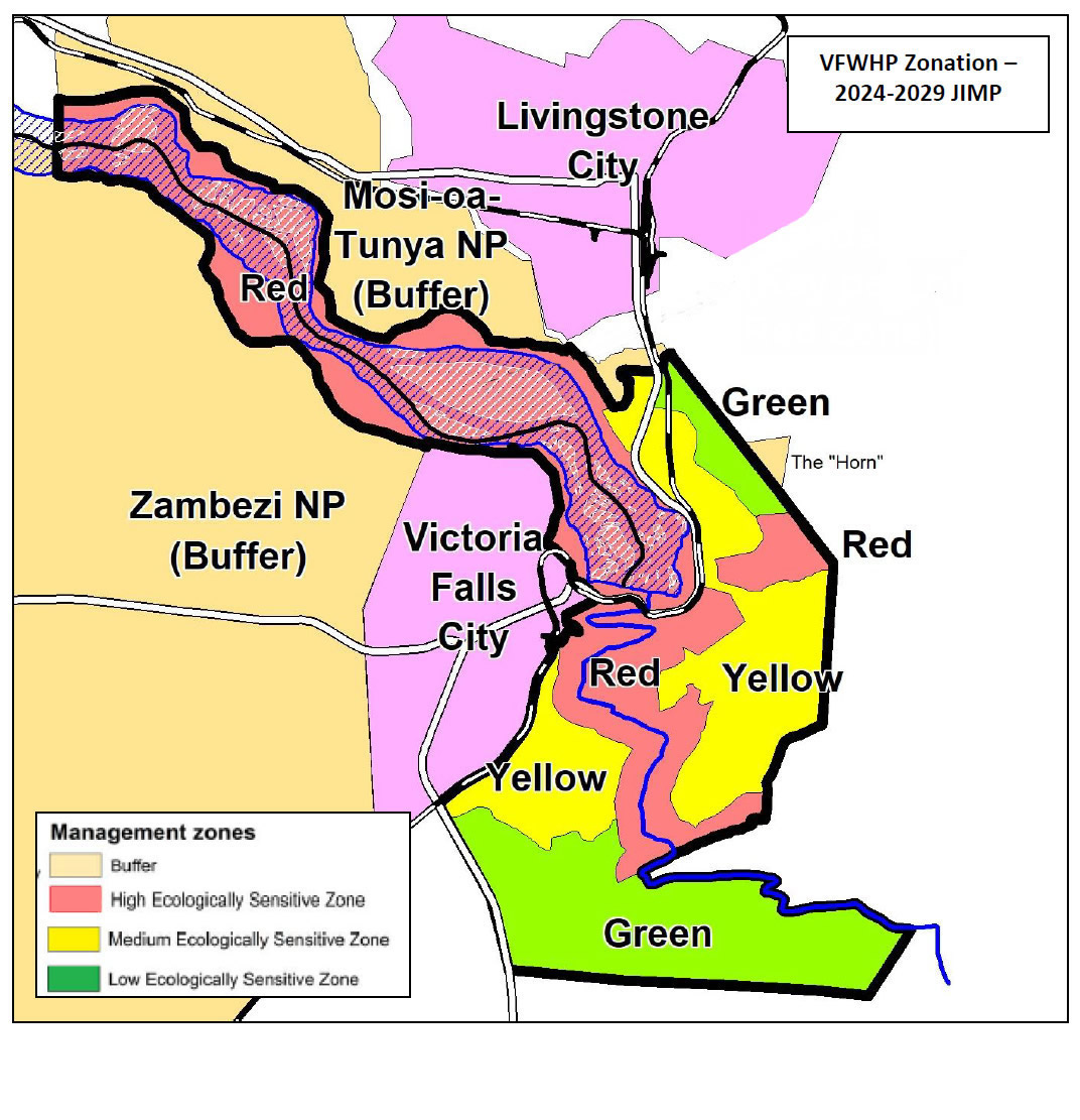
Map showing proposed (amended) boundary and management zones
for the Victoria Falls World Heritage Site
(from 2024 Victoria Falls/Zambezi National Park Management Plan, p.22)
[click image for larger view].
‘Green Belt’
The Plan appears to completely overlook the permanently protected area established under the 1975 Victoria Falls Outline Plan (and confirmed in the 2001 Victoria Falls Combination Plan), referring to the area identified as Rural/Open Space under the 1975 Plan simply as ‘Green Belt’ with no specific protection.
“The northern half of the City has tourism development areas, agricultural land, a golf course and land designated as ‘green belt’. The green belt area represents 18% of the City but is becoming less attractive to wildlife as it gets eroded and also blocked by riverine developments, both in the City and the National Park.” (ZPWMA, 2024, p.23)
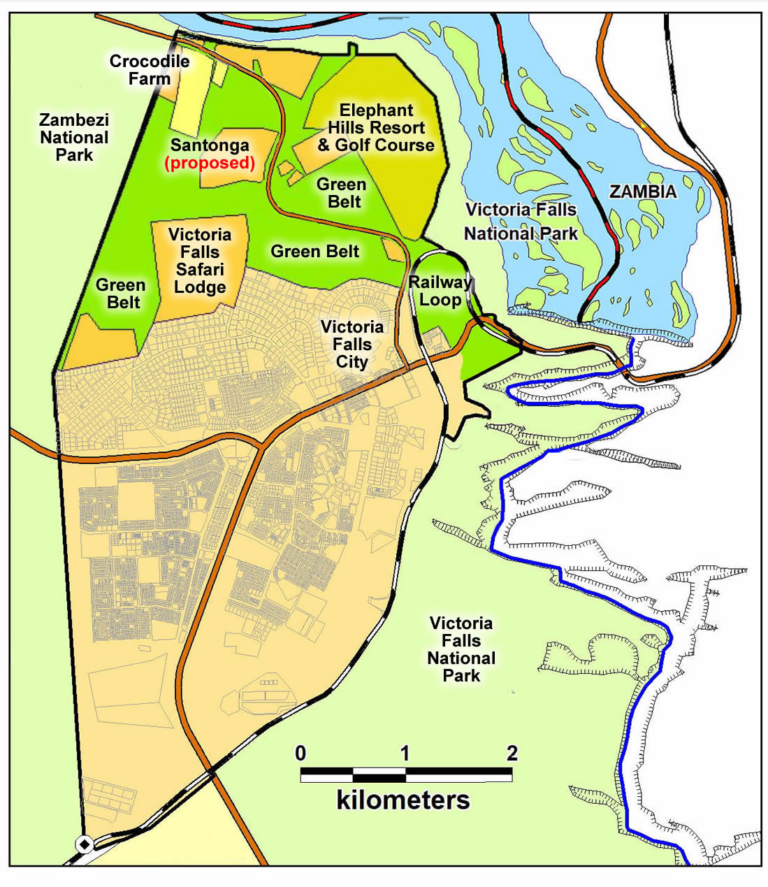
Map showing northern part of Council-controlled area
(adepted from 2024 Victoria Falls/Zambezi National Park Management Plan, p.23)
[click image for larger view].
The Plan highlights increasing development pressures within this Council-controlled area and highlighted concerns over the future of the entire open area.
“The northern part of the city is a mosaic of land loosely designated as ‘green belt’ and other land allocated for tourism and agricultural purposes. The extent of the green belt has been eroded since the 1970s and there are several undeveloped plots in the middle of it. Without a clear definition of developments and a publically available map of the green belt it is possible that there will be continual erosion of the land available for conservation and animal movements within the city. Once finalised, the green belt needs to be legislated to stop future attacks on its integrity.” (ZPWMA, 2024, p.66-7)
In relation to the mitigation of people-wildlife conflict the report emphasised:
“Access to the river by wildlife through the green belt in the City needs to be maintained, especially as one of the well-used crossing points is between the Zambezi NP boundary and the Victoria Falls.” (ZPWMA, 2024, p.42)
Riverside Camps
The Park Plan confirmed that due to the development of tourism concessions in the upstream Zambezi National Park (Kandahar, Mpala Jena and Sansimba - the later two upstream and outside of the WHS), there are no longer any camping sites available along the riverside for independent or guided visitors.
“Camping at ZPWMA facilities is no longer possible on the Zambezi River but is permitted in Chamabonda Vlei. The first tourism concession was issued in 2006 and to date there are over 30 leases in both parks. Many of these leases are for 25 years and most are limited to an exclusive area of 1 km².” (ZPWMA, 2024, p.13)
The camp sites were popular with local residents and multi-day canoe and safari tours along the upper river often operated by smaller independent operators. The Plan goes on to detail:
“Starting in 2006, the ZPWMA started issuing accommodation related leases in the Zambezi and Victoria Falls National Parkss in response to a growing demand. The first were Tsowa and Chundu Islands and Zambezi Sands (Chomunzi) in Zambezi National Park and a large concession Victoria Falls A (in 2007). Seven more leases were issued up until 2010. After almost a decade with no leases issued, a new round of lease allocations started in 2017 and 22 leases were issued in the next 5 years. This included the conversion of the three public camping sites and two of the picnic sites in the east of the park... There are a number of leases that were issued in between 2016 and 2020 where few or no developments have taken place (e.g. Tree Lodge, Picnic Sites 21-25, Chundu 1, Viewpoint). The reasons for this are unclear...
“The eastern corner of the Zambezi National Park which is close to Victoria Falls is the part that is most visited. Unfortunately the allocation of exclusive sites means that access to the river along the first seven kilometres is restricted and the roads have actually been realigned to direct traffic away from the river.” (ZPWMA, 2024, p.54-5)
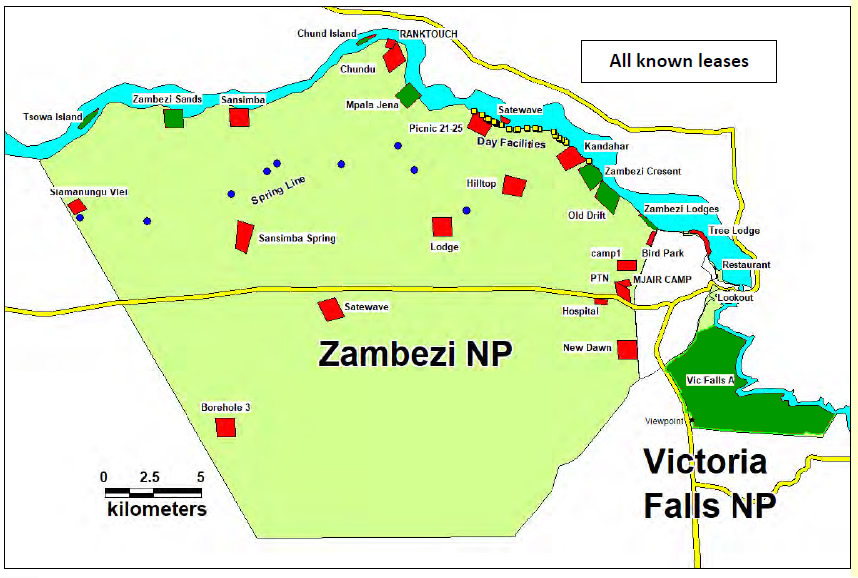
Map showing tourism concessions within the Zambezi and Victoria Falls National Parks
(existing - green, proposed - red)
(adapted from 2024 Victoria Falls/Zambezi National Park Management Plan, p.23)
[click image for larger view].
The Plan makes reference to a proposal to develop two picnic sites close to the existing Kandahar Camp (and within WHS HESZ) as a new camping site.
“Two of the picnic sites adjacent to Kandahar site have been ear-marked for development as a public campsite.” (ZPWMA, 2024, p.55)
Dr Mangwanya, Director-General of the Zimbabwe Park and Wildlife Management Authority, has also previously indicated plans to ‘upgrade’ picnic sites No.4 and 10 as tourism concessions (Victoria Falls Bits and Blogs, 25th February 2021).
River Jetty Issues
The 2024 National Park Plan for the Victoria Falls and Zambezi National Parks highlighted particular concern over riverside developments within the Victoria Falls National Park and World Heritage Site ‘Highly Ecologically Sensitive Zone’ running upstream from Elephant Hills Resort to the Zambezi National Park. This is probably the most vulnerable section of the upstream riverine fringe included within the WHS, with just a narrow strip of riverine fringe protected within the Victoria Falls National Park and WHS. It is also the most impacted affected section from tourism developments.
“There are about 60 boats operating out of probably 20 jetty sites in the ViFNP. In addition, there are also jetty sites inside the ZNP, one recently allocated. Boat cruises operate at peak times of early morning and late afternoon and are limited in their area of operation by the rapids near Kandahar Island. Most of the jetty sites are spread along approximately 1.5 km of the river front between the city water intake and the ZNP. At this point the boundary of the Victoria Falls National Park is very narrow (approx. 50 m of dry land south of the high water mark) and is defined as a line between beacons. Some jetty sites have expanded into the Victoria Falls Council area and some have developed restaurants and other tourism facilities. The legalities of these developments is not clear, and the boundaries of the sites is also not clear. A recommended solution would be a proper survey of all sites for inclusion into the master plan. Limits of use for the sites need to be defined as well as codes of conduct for operation of the boats. In addition, rules for sewage and hard waste disposal need to be formalised and enforced through detailed waste management plans for all jetty sites and boats.” (ZPWMA, 2024, p.67-8)
In addition to the protection given under National Park status, and the WHS HESZ, a 150m wide strip from the river edge is supposedly protected from development under planning guidelines (World Heritage Committee, 2010). This protection appears to have evaporated in recent years, with many south-bank riverside developments infringing within this zone, including many smaller developments which have grown from jetty sites (Pure Africa Eatery, Zambezi House) in addition to hotel and lodge developments (A’Zambezi and Palm River Lodge).
Further development in this area will fragment and degrade the visual and tourism value of this whole section, which has already been significantly impacted by existing developments.
Island Intrusions
Increasing tourism activities on the islands on the lip of the Falls were also identified as being 'highly intrusive'.
“Decisions need to be taken regarding developments and activities on the lip of the Falls, across from the Rain Forest. The situation is complicated by the fact that 30% of the Rain Forest looks over the Zambian portion of the Falls. In the late 1990s a Zambian operator established a seasonal tented camp on Livingstone Island directly adjacent to viewpoint 13 and markets swimming on the lip of the Falls in the “Devils Pool”. Although numbers are limited (six trips per day with 24 guests) this is a highly intrusive development and activity that impacts on the Falls experience for millions of visitors. Currently contested and in court is a proposal for a similar activity on Cataract Island in Zimbabwe. Decisions need to be taken about the long-term effects of this type of activity on the primary income generation area for the ZPWMA.” (ZPWMA, 2024, p.68)
Helicopters and Helipads
Flights over the Victoria Falls, particularly helicopters, were also identified as highly intrusive upon the visitor experience.
“There needs to be clear and unequivocal limits of use for developments and activities. Key intrusive tourism activities include boat cruises and aerial flights over the falls and these are discussed briefly below.
“Currently there are six helicopter companies - 4 in Zimbabwe and 2 in Zambia – with possibly 15 helicopters - 10 in Zimbabwe and 5 in Zambia. The recent entrant to the industry is a 50:50 Joint Venture with the ZPWMA. At the moment there are no official restrictions for helicopter management, apart from the rule of being 500 feet above a protected area and the Falls airspace is a Special Rules Area with a minimum flight height of 4,000 feet, which applies to operators from both Zimbabwe and Zambia. There is a ‘gentleman’s agreement’ regarding flight times - between 8am and 5pm with a break between 1pm and 2pm but presently nothing enforceable. The location of helipads has a direct bearing on their level of intrusiveness as it will impact on their flight paths. There are instances of helicopters flying over and disturbing wildlife in contravention of the 500 foot restriction. Noise pollution is one of the key issues affecting tourist satisfaction in the Falls and it needs to be addressed.
"Possible solutions could include relocation of helipads, restrictions on numbers of flights, higher height operating levels, strict ‘banking’ rules etc. Implementation of these would have to a trade-off between the economics of the experience and dissatisfied customers on the ground. There is also pressure to establish helipads in the Zambezi NP. These should be resisted.” (ZPWMA, 2024, p.67)
Council Expansion
The Plan highlighted development pressures within the Council-controlled area and opening up of new residential stands along Wood Lane and raised concerns over the future of the entire open area stretching north to the River.
“Unfortunately, and in the absence of an agreed vision and Master Plan for the city, it appears that the Victoria Falls City Council is reacting to pressure for development by opening up new areas for stand and housing development in the previously designated green belt. Stand delimination and development is already underway north of Wood Lane. Realistically it seems likely that further areas will be opened up in the future which leads one to the conclusion that the whole of the green belt will suffer the same fate over time. If this is the case, then thought should be given to the fencing of, at the very least, the residential areas of the town - difficult task. Ideally the green spaces should remain open but give development pressure this may not be possible.” (ZPWMA, 2024, p.23-4)
The Plan also hinted at the proposed expansion of the Council-controlled area into the Zambezi National Park.
“The City is seriously constrained for space, especially in the light of the drive for continued expansion. The Council is addressing this in several ways. Firstly, there is a drive for redevelopment and revitalisation of existing areas within the confines of the town. This will require upgraded infrastructure and new, innovative designs to maximise the effective use of the land to accommodate the expected increase of permanent residents. The second option is to expand into the surrounding areas and there is a proposal from the Victoria Falls City Council requesting land on the eastern boundary of the Zambezi National Park. Other proposals include southward expansion into the Panda Masue State Land and also into the Communal Land (Monde).” (ZPWMA, 2024, p.59-60)
Carrying Capacity Concerns
The new Plan highlighted the growing pressures of increasing visitor numbers, indicating that the south bank limit of 500 visitors at any one time was likely being exceeded during peak periods.
“There will also be a point where the experience for the visitor becomes degraded. Previous studies capped the annual visitor numbers for this fragile ecosystem at 100,000 to 150,000 per annum. The current JIMP sets a max limit at 500 people at any one time but this is likely to have been significantly exceeded at peak times - for example, 1,700 visitors per day recorded over the Christmas period in 2013. Detailed records of Rain Forest entries were not available which hampered the analysis of visitor flows. Ideally it should be possible to assess visitor flows on an hourly basis throughout the day. This data will be important going forward to devise a system of visitor control to conserve the Rain Forest given the huge influx of visitors expected.” (ZPWMA, 2024, p.56)
Accepting a daily limit of 3,000 visitors either side of the Victoria Falls, the drive to expand tourism accommodation on the south-bank resort towards 6,000 beds would suggest that the carrying capacity of the ‘Rainforest’ is in danger of being regularly breached during peak-season periods, when hotels and lodges are often booked to or near capacity and assuming an average two-day stay.
Serious caution therefore needs to be expressed in relation to Government supported initiatives to further expand bed capacity at the resort in order to achieve ambitious and unrealistic national tourism revenue targets (Victoria Falls Bits and Blogs, 4th June 2024).
With the highly seasonal nature of tourism to the Falls more detailed reporting and analysis of tourism visitor patterns is required from the State Parties to calculate accurate carrying capacities and assess and monitor tourism levels. It should be noted that actual tourism infrastructure, such as toilet facilities, have not been expanded since the 1990 estimates by Heath.
Next: The 2024 Victoria Falls Council Master Plan
References
Links to external sites or pdf downloads, open in a new window.
Roberts, P. (2026) Paradise Lost? Conservation and Development of the Victoria Falls (1900-2025). First Edition, February 2026. Zambezi Book Company / CreateSpace Independent Publishing.
Zimbabwe Parks and Wildlife Management Authority (May 2022) ZPWMA VF-ZNP Planning Meeting May 2022 (pdf download [8mb], opens in a new window)
Zimbabwe Parks and Wildlife Management Authority (2024) Zambezi/Victoria Falls National Park General Management Plan (2024-2034). April 2024. (pdf download [8mb], opens in a new window)