Keep Victoria Falls Wild
The Victoria Falls - A Natural Wonder
Geology and Geography
Geology
Geography
Ancient Origins
Africa's Oldest Dinosaur
Geology
The breakup of the Gondwana supercontinent into the southern hemisphere continents (Africa and South America) during the Jurassic Period about 180 million years ago led to the formation of the extensive basaltic rocks of the Karoo basalts which underly the wider area (Bond 1973; 1990; Stagman 1978).
“The geology of this trans-boundary property is a product of volcanic action that characterized much of Southern Africa about 200 million years ago during the Karoo Period (Meynell et. al., 1996, Bond, 1990). The lava flows produced during this period formed the basalt plate underlying the rocks. These basalts are subsequently overlain by a thin layer of arid and/or marine sandstones and the red Kalahari sands. Chalcedony and surface limestones are also found as isolated rocks or constituent minerals. This geology has a major effect on the vegetation of the area (Fanshawe, 1975).” (State Parties, 2016b)
The 2021-2030 SESIA expands:
"At the Falls, the basalt stretches 200 km from Kazungula on the Botswana Border to the Matetsi River confluence in the Batoka Gorge. The basalts are a succession of lava flows in a limited interval which resulted in a plateau on which several gorges were incised by rivers including the Zambezi River. At the Batoka proposed Dam, 13 nearly horizontal lava flows with thickness varying between 10 to 80 m were recorded (Bond 1973). The thickness [depth] of the basalts at Victoria Falls is not known since the bottom has not been exposed, but it is estimated to be more than 300 m (Bond 1990).
"The eruption of the basaltic lava was estimated to be over a short interval thereby minimizing the possibilities of sedimentary deposits between the basaltic successions. Several giant cracks or joints however developed on the surfaces of the basaltic lavas as they cooled down. Some of the cracks were interconnected. The joints were further developed by faulting due to effects of the East African Rift Valley system. The resultant fissures (faults and joints) were filled by sediments which consolidated into soft sandstone as compared to the hard basalt. The sandstone within the joints was later eroded by rivers leading to the formation of rapids and gorges along the Zambezi valley including at Victoria Falls (Bond 1990).
"There are two distinct types of basalts at Victoria Falls. Type one is fine-grained dark bluish rock (Bond 1973; Bond 1990; Stagman 1978). Second type is purplish red rock with almond shaped inclusions of white minerals often coated with a green skin. Type one forms bare cliffs with strong vertical jointing in the walls of the gorges while type two forms bands of up to 6 m thick between the thicker type one outcrops (Bond 1990).
"The basalt is overlain by 1 or 2 m thick chalcedony, which was the source of stone tools for the early inhabitants (Stagman 1978). Piped sandstone which is perforated by round pipe or holes overlies the chalcedony layer. Beds of the Kalahari Sands which are a mass of red unconsolidated wind-blown sand form the top most layer. The thickness of the Kalahari beds is not known but from boreholes along the Victoria Falls-Bulawayo Road they exceed 100 m (Stagman 1978).
"In summary, the falls is known for its geological exposure of basalt rock formation of Early Jurassic in age (about 180 - 200 million years ago) when hot magma (lava) oozed out of the earth’s interior to form layered basalts, which in places are massive."
The local geology of the Falls is characterised by two main formations:
"There are two main rock formations namely Karoo basalts and Kalahari Sands in the Victoria Falls Area (Figure 6.2). Basalts are well exposed along the Zambezi River and its tributaries. Thick succession layers of the flows of the basalts are clearly exposed on the banks of Zambezi River at the Victoria Falls Bridge (Figure 6.1). The rocks are easily distinguished by the dark brown to black colour as well as the gorges they form. There are many joints and fault lines and water springs developed on some of them. The basalt rock weathers into black clay soil which is the dominant soil in the several streams in the area. Further up away from gorges and rivers the basalt is overlain largely by the Kalahari Sand.
"Pebbles of chilled piped sandstone and chalcedony are not uncommon above basalt rocks. This implies that at some areas the basalt was once overlain by chalcedony and piped sandstone. The basalts are overlain by Kalahari Sands. Kalahari Sands consist of fine-grained clean and well-rounded quartz particles. The Kalahari Sands occupy most of the flat area above the gorges and form most of the ridges in the area. There is distinct scarp at the contact of Kalahari Sands and basalts as a result of the retreat of the former due to erosion."
Geography
The physical geography of the Falls region is dominated by the Zambezi River.
"The Victoria Falls World Heritage Property and the surrounding area is the first order land mass called the African Plateau. The north-western part of the park has two third order forms slightly dissected further away from the river. The south-western portion, close to the Falls area, is an undulating plateau interrupted in various places by hills, ridges and minor escarpment."
"The relief of this whole region is dominated by the Zambezi River, the Falls and the downstream gorges. To a large extent these features are the basis for the UNESCO declaration of the area as a World Heritage Property. The Victoria Falls and gorges are the most important natural features of the park and of an exceptional significance internationally, hence the site where they are found was declared a WHP in 1989." (State Parties, 2016b)
The most noticable feature of the river is undoubtedly the Victoria Falls, marking a sudden and dramatic change in the nature of the river above and below the Falls.
"Victoria Falls lies in the Zambezi Valley in the south-west of Zambia and north-west of Zimbabwe. The terrain is dominated and shaped by the mighty Zambezi River which flows about 2,700km from its source in the Mwinilunga District of north-western Zambia to the Indian Ocean passing through Angola, Botswana, Zambia, Zimbabwe and Mozambique (Key et al 2015; Phillipson 1990). As the river flows down to the ocean it sculptures the landscape into flat valleys and gorges. The main landform features therefore within the 30 km radius of Victoria Falls are waterfalls, gorges, islands, drainage system (rivers and their tributaries), hills, ridges, springs and flat ground. The mighty Victoria Falls and the subsequent gorges are the prominent features of the study area. The falls and the gorges which were formed as a result of erosion of weak sand beds within the basalt rocks are awesome both from the land and air. There are a number of Zambezi tributaries below the Victoria Falls and they form gorges where they meet the Zambezi River. The distribution of the tributaries was largely controlled by faults within the basalts.
"As a result of the geological history of the area, the Zambezi River flow was captured, creating a site that contains superlative natural phenomena of exceptional natural beauty and aesthetic importance. One of such was a creation of the largest curtain of naturally falling waters in the world forming a spray of water that forms a cloud visible up to 30 to 50 kilometers away making it one of the seven natural wonders of the world ." (State Parties 2021, p,25-29)
The river above the Falls is wide and shallow and characterised by rapids and islands.
"Rapids are formed where the river flows across basalt rock. As the river flows over the resistant basalt rock which cuts across the river channel there will be more erosion of weak sandstone lenses sandwiched between basaltic layers thereby creating rapids. There are therefore several rapids along the river as the river encounters basalt rocks in several places (Phillipson 1990).
"The basalt is faulted with numerous fractures (Figure 6.4) that has led to gorges (Kagosi M., and Nyambe I.A, 2020) and islands as features of outstanding international geological heritage and universal values of the mighty Zambezi River, which resulted into changing positions of the waterfall after an average period of 40 thousand years as the falls retreated (Figure 2). These outstanding universal values led to the Victoria Falls declared as a World Heritage Site in 1989.
"The gorges below the falls are dramatic and scenic landscape features themselves forming a zig-zag scar of the landscape (Bond, 1990; Phillipson, 1990).
"Islands are found above the Victoria Falls. Basalt outcrops or sand dunes form islands e.g., Kandahar Island which is covered by vegetation. Sandy islands have more vegetation cover than the basaltic ones (Phillipson, 1990)." (State Parties 2021, p,25-29)
Below the Victoria Falls a series of zig-zagging gorges extend downstream, with the river now constricted into a deep and narrow channel.
"The Victoria Falls and gorges are the most prominent features in the area. The waterfall forms a cloud which is visible from about 50 kilometers. The gorges below the falls are dramatic and scenic landscape features themselves forming a zig-zag scar of the landscape (Bond 1990; Phillipson 1990). The formation of the Victoria Falls and gorges in general was a result of the combination of the development of the Zambezi River and the morphology of the basalt. The presence of joints aided by faults in the basalt rock facilitated the formation of Victoria Falls. Predatory waters of the combined Lower and Upper Zambezi River eroded sandstone layers which had been deposited in the joints and faults of the basaltic rocks. As erosion progressed basaltic blocks were removed resulting in nexus of joints causing river retreat as well as development of gorges and waterfalls. The process is still ongoing (Bond, 1990). Over the thousands of years, the river has created the scouring, erosive and depositional characteristics that are of geological significance and of scenic value for geoheritage tourism." (State Parties 2021, p,25-32)
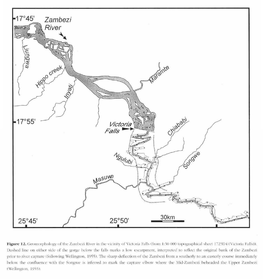
Geomorphology of the Zambezi River at Victoria Falls (Moore and Larkin, 2001, Fig.12)
[click image for larger view]
Ancient Origins
Research published in 2015 traced the evolution of the modern Zambezi River to ancient origins during the Palaeozoic Era before 280 Ma (million years ago), making the river the oldest currently known river in the world (Key, Cotterill & Moore, 2015).
"Africa's Zambezi is now established as Earth's oldest known river – the direct descendent of an ancient Proto‑Zambezi river. The origins of the Zambezi have been deciphered from geological evidence across the vast wilderness of the Chicoa, Gwembe, Luangwa, Mana and Sebungwe valleys of south‑central Africa; here, rock formations and landforms preserve the central repository of the river’s history back into the Palaeozoic Era before 280 Ma (million years ago).The Proto-Zambezi river originated in the drainage system that was established as vast Dwyka ice-sheets were receding across the super-continent of Gondwana. At this time the immense highlands of the Trans-Gondwana mountains directed the westerly flow of glacial meltwaters into the interior of Gondwana. With its catchment entirely contained within Gondwana, this massive river sustained a vast, inland sea centred on modern‑day Botswana...
"An unbroken chain of evidence places a minimum age of 280 Ma on the Zambezi's origins, when Gondwana’s ice-sheets began to melt as the super-continent drifted northwards. Central Africa’s rift valleys preserve the rock ledgers (historic record) that tell us the Proto‑Zambezi existed long before Africa became a continent. Importantly, this geological record of the ancestral Proto‑Zambezi is contiguous with the modern river. In particular, the evidence reveals that precursors of the modern Luangwa and Middle Zambezi already existed in the early Permian. This geological record in the Luangwa and Middle Zambezi valleys (the central African rifts) has survived despite the complete reversal of the Zambezi’s flow caused by Gondwana’s breakup, which forged the African continent.
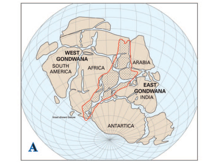
The central location of the Trans-Gondwana Mountain Belt within the Gondwana Supercontinent (based on the reconstruction by Reeves, 2009). (Key, Cotterill and Moore, 2015, Fig.2) [click image for larger view]
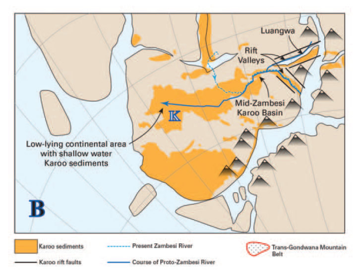
(B) Early Permian palaeogeography of the Proto-Zambezi River across Western Gondwana (from Smith, 1984; Guillocheau et al., 2013a); the blue lines trace the approximate course of the river into the Kalahari Basin (K). (Key, Cotterill and Moore, 2015, Fig.2) [click image for larger view]
"The greatest change in over 280 million years of the Zambezi’s evolution entailed the complete reversal of its flow. The process of break up was protracted, as over millions of years, river by river, flow in the Proto‑Zambezi’s catchment was redirected into the Indian Ocean, to reduce the significance of the Proto‑Zambezi’s inland terminus (in central Botswana)...
"Geologically recent captures of the Chobe, Kafue and Upper Zambezi testify to the relative youth of the (modern) river’s topology. The Great Equatorial Divide on Africa’s high plateaux comprises the Zambezi’s modern watershed, and its present position testifies to repeated re-shuffles of links between long lived rivers. To summarize, we now estimate the modern Zambezi basin to be barely 250 thousand years old...
"Its status as Earth’s oldest, big river – yet known – underwrites the conservation status of the Luangwa‑Zambezi wilderness. The geological continuity preserved across these landscapes reveals how the ecosystems of the Zambezi have endured in an unbroken chain, ever since the first ecosystems of Dwyka times formed along glacial streams. The criterion of Ancient Evolutionary Heritage positions the Zambezi as a unique outlier among Earth’s most spectacular landscapes, including the Grand Canyon. One is challenged to name World Heritage Sites that match these iconic values, in preserving comparable geological and paleoecological records." (Cotterill, Moore & Key, 2016)
The ancient history of the Zambezi is recorded in the geological record of the Luangwa and Middle Zambezi valleys, where formations pre-dating the break up of Gondwana are exposed.
"This geological record in the Luangwa and Middle Zambezi valleys has survived despite the complete reversal of the Zambezi’s flow caused by Gondwana’s breakup, which forged the African continent. Around 200 million years ago, for a period of 100 million years, a flowing mass of lava began to emerge from within the earth — the Stormberg lavas. Fluid enough to flow over the land and fill hollows, troughs and valleys, it left behind an almost horizontal aspect, trapping sandstones beneath.
"Eventually an area of at least 2,000,000 square kilometres were covered by these various lava sheets to a depth of perhaps nearly 1000 metres deep at Victoria Falls and up to 9000 metres elsewhere! This basalt was subjected to great stress due to cooling and regional tectonic activity. This stress caused deep fracturing and lines of weakness, and it is these that the growing Zambezi river would come to exploit in its course via river capture. (Victoria Falls Bits and Blogs, 3rd February 2018)
Africa's Oldest Dinosaur
In September 2022 it was announced that scientists had unearthed the remains of Africa's oldest known dinosaur in the Middle Zambezi Valley and which lived more than 230 million years ago and thought to be part of the early lineage that gave rise to the sauropod dinosaurs, which includes the diplodocus and the brontosaurus, and the largest animals to have lived on land.
"The Mbiresaurus raathi was one metre tall, ran on two legs and had a long neck and jagged teeth. Scientists said it was a species of sauropodomorph, a relative of the sauropod, which walked on four legs. The skeleton was discovered during two expeditions, in 2017 and 2019, to the Zambezi Valley.
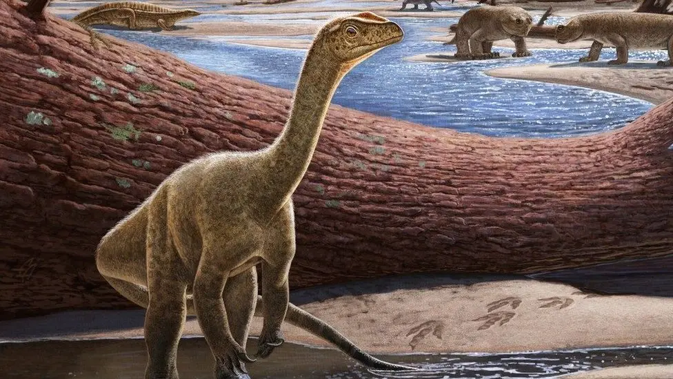
An artistic representation of the Mbiresaurus raathi (BBC News, 1st September 2022)
[click image for larger view]
"'When we talk of the evolution of early dinosaurs, fossils from the Triassic age are rare,' Darlington Munyikwa, deputy director of National Museums and Monuments of Zimbabwe, and who was part of the expeditions, told the BBC. He said that fossils from that era - which ended more than 200 million years ago - had been unearthed in South America, India and now Zimbabwe." (BBC News, 1st September 2022)
The near-complete skeleton of the Mbiresaurus raathi is thought to date to the Carnian stage of the Triassic period, when today's Zimbabwe was part of the massive supercontinent Pangaea.
In 2024 it was announced that another species of sauropodomorph dinosaur had been discovered on Spurwing Island, Lake Kariba, named Musankwa sanyatiensis.
"The paleontologists found the remains of Musankwa sanyatiensis — a single hind leg, including its thigh, shin, and ankle bones — at the Spurwing East Palaeosol site of the Pebbly Arkose Formation, situated on the north-eastern shoreline of Spurwing Island, Lake Kariba, Mid-Zambezi Basin, Zimbabwe." (Sci News)
"The single specimen... comprises a right femur, tibia, and astragalus and exhibits a distinctive combination of features setting it apart from other Late Triassic massopodan sauropodomorphs. Phylogenetic analysis positions Musankwa as the earliest branching member within Massopoda. (Nature, 24th June 2024)
Musankwa sanyatiensis is estimated to have weighed about 390 kg, stood 1.5m high at the hip and around 5m long from the tip of the snout to the tip of tail. It lived 210 million years ago, during the Late Triassic, before the end-Triassic Extinction which wiped out 70% of Earth's species. The group of sauropodomorph dinosaurs appear unaffected by the extinction event.
This marks the fourth dinosaur species named from Zimbabwe's Karoo-aged basins, underscoring the region's significant potential for yielding further dinosaur fossils.
"Over the last six years, many new fossil sites have been recorded in Zimbabwe, yielding a diverse array of prehistoric animals, including the first sub-Saharan mainland African phytosaurs (ancient crocodile-like reptiles), metoposaurid amphibians (giant armored amphibians), lungfish, and other reptile remains." (Sci News, 30th May 2024)
References
Links to external sites or pdf downloads, open in a new window.
BBC News (1st September 2022) Africa's oldest dinosaur found in Zimbabwe.
Cotterill, F.P.D., Moore A.E. & Key R.M. (2016) On the Antiquity of the Zambezi River, its Rifts, and its Wilderness. The African Fisherman, Issue 172, April/May 2016, p.31-35.
Cotterill, F.P.D., Moore A.E. & Key R.M. (2015) The Zambezi River An Archive Of Tectonic Events Linked to the Amalgamation and Disruption of Gondwana and Subsequent Evolution of the African Plate. South African Journal of Geology.
Moore and Larkin (2001) Drainage Evolution in South-Central Africa Since the Breakup of Gondwana. South African Journal of Geology, Volume 104, p.47-68.
Moore and Cotterill (2010) Victoria Falls: Mosi-oa-Tunya – The Smoke That Thunders. In Migon, P [Editor] (2010) Geomorphological Landscapes of the World. Chapter 15.
Moore, A E, Cotterill F P D, Main, M P L, and Williams H B. (2022) The Zambezi River. In Gupta, A [Editor] (2022) Large Rivers - Geomorphology and Management. Second Edition. Chapter 16. John Wiley & Sons, Ltd, England.
Nature (24th June 2024) Dinosaur fossil unearthed in Zimbabwe.
Sci News (30th May 2024) New Sauropodomorph Dinosaur Unearthed in Zimbabwe.
State Parties (2016) 2016 Victoria Falls/Mosi-oa-Tunya State of Conservation Report and 2016-2021 Victoria Falls/Mosi-oa-Tunya Joint Integrated Management Plan (external download, opens in a new window).
State Parties (2021) 2021-30 Strategic Environmental and Social Impact Assessment Report, Victoria Falls World Heritage Property (pdf download [9 mb], opens in a new window)
Victoria Falls Bits and Blogs (27th March 2017) Ancient Origins - Evolution of the Zambezi.
Victoria Falls Bits and Blogs (3rd February 2018) Zambezi River flowed before the dinosaurs roamed.